Filter: Categories of Wisconsin Historical Images
Filter: County of Vernon
Filter: Subject of land use
Filter: Categories of Wisconsin Historical Images
Filter: County of Vernon
Filter: Subject of land use

| Date: | 1958 |
|---|---|
| Description: | Aerial view of contour strip farming with the Obert Olstad farm in foreground. The Carl Backum farm is in the background. |
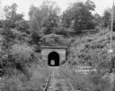
| Date: | 1924 |
|---|---|
| Description: | View from railroad tracks through covered railroad tunnel in hill. A sign on a telephone pole on the right reads: "Private Property / Thoroughfare / Keep O... |
| Date: | |
|---|---|
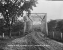
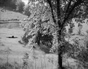
| Description: | View down a metal bridge over the Kickapoo River showing a truck parked on the far side of the bridge. A man and a boy are standing at the rail of the brid... |
| Date: | 1909 |
|---|---|
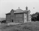
| Description: | Exterior view of the public school. A large brick building with a bell tower on the roof, arched entrances, and a wooden fence along the side. |
| Date: | 1924 |
|---|---|
| Description: | View of an empty baseball park with a bluff in the background. |
| Date: | 1924 |
|---|---|
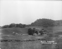
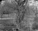
| Description: | Long view of bluffs with a fence and a farm in the foreground. |
| Date: | 05 30 1965 |
|---|---|
| Description: | Pasture hillside with 2-wheeled cart and a tree in the foreground. |
| Date: | 09 07 1964 |
|---|---|
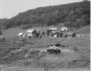
| Description: | Farm buildings in the Coulee country, with old tractor in foreground. |
| Date: | 05 17 1966 |
|---|---|
| Description: | A fence made of old wagon wheels above a stone retaining wall. |
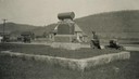
| Date: | 1925 |
|---|---|
| Description: | A man kneels next to a monument dedicated to the pioneers. |
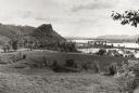
| Date: | 1953 |
|---|---|
| Description: | View across fields towards the Genoa Dam on the Mississippi River. Tree-covered hills are on the left. |
| Date: | 1885 |
|---|---|
| Description: | Stereograph of Courthouse Rock. |
| Date: | 04 1930 |
|---|---|
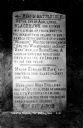
| Description: | View of a historical marker commorating Black Hawk's surrender in 1832, located on Highway 35. Caption reads: "Tablet on Highway #35 * Victory, Wis." |
| Date: | 1927 |
|---|---|
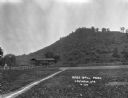
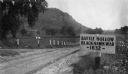
| Description: | View of the Battle Hollow sign along an unpaved road. In the distance on the left is a rock formation covered with trees. Sign reads: "Battle Hollow Clack ... |
| Date: | 1930 |
|---|---|
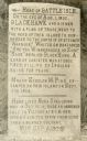
| Description: | View of the historic site marker on Highway 35 indicating the location of Bad Axe Battlefield. Caption reads: "Tablet on Highway #35 * Victory, Wis." |
| Date: | 1960 |
|---|---|
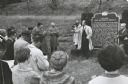
| Description: | Senator Hubert Humphrey of Minnesota campaigning for the presidential nomination in southwestern Wisconsin. Humphrey stands at the historical marker in Co... |

| Date: | 1935 |
|---|---|
| Description: | Farmer operating a horse-drawn hay rake in a field. |

| Date: | 1930 |
|---|---|
| Description: | A winter view of "The Three Chimneys" in the St. Peter sandstone formation. |

| Date: | 1930 |
|---|---|
| Description: | A tree-lined, rural road in the Kickapoo Valley of southwestern Wisconsin. |
If you didn't find the material you searched for, our Library Reference Staff can help.
Call our reference desk at 608-264-6535 or email us at: