Filter: Categories of Wisconsin Historical Images
Filter: County of Vernon
Filter: Subject of cities and towns
Filter: Creator Name of Unknown
Filter: Categories of Wisconsin Historical Images
Filter: County of Vernon
Filter: Subject of cities and towns
Filter: Creator Name of Unknown
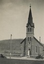
| Date: | 04 28 1925 |
|---|---|
| Description: | Exterior of church with people walking toward the entrance. |
| Date: | 1925 |
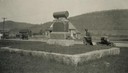
|---|---|
| Description: | A man kneels next to a monument dedicated to the pioneers. |
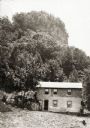
| Date: | 1920 |
|---|---|
| Description: | House built by an early Italian settler. At the time of the photograph, the home belonged to Mrs. Margaret Gelarde. Behind the house is a hill and rock for... |
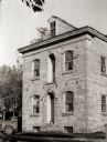
| Date: | 1920 |
|---|---|
| Description: | Exterior view of an early stone house. An automobile is parked on the left side of the building. |
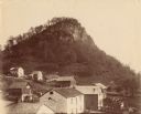
| Date: | |
|---|---|
| Description: | View of various buildings in Genoa. Behind the buildings is a tall rock formation covered with trees. |
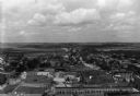
| Date: | 1910 |
|---|---|
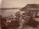
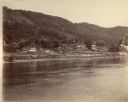
| Description: | Elevated view of Genoa along the Mississippi River. Scene of the last battle between the United States forces and the Native Americans under Chief Black Ha... |
| Date: | 1885 |
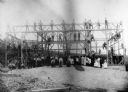
|---|---|
| Description: | Group of barn raising participants posed in front of the structure in progress. |
| Date: | 1885 |
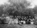
|---|---|
| Description: | Seated group of women and children participating in a barn raising. |
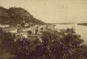
| Date: | |
|---|---|
| Description: | Elevated view form hill of the town of Victory on the bank of a river. |
| Date: | 1925 |
|---|---|
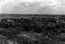
| Description: | Elevated view of Viroqua. Commercial buildings are in the foreground, with houses among trees in the background. |
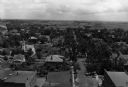
| Date: | 1925 |
|---|---|
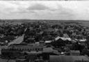
| Description: | Elevated view over rooftops of Viroqua. Commercial buildings are in the foreground, with a street on the left. |
| Date: | 1920 |
|---|---|
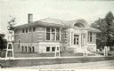
| Description: | Exterior view from road towards the Viroqua Public Library. Young trees along the sidewalk have have protective supports around them. Caption reads: "Viroq... |
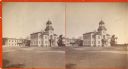
| Date: | 1920 |
|---|---|
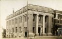
| Description: | Exterior view from intersection towards the First National Bank on a street corner. A building next to the bank on the right has a sign that reads, in part... |
| Date: | |
|---|---|
| Description: | View across the river towards buildings along the shoreline in Victory. |
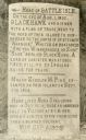
| Date: | 04 1930 |
|---|---|
| Description: | View of a historical marker commorating Black Hawk's surrender in 1832, located on Highway 35. Caption reads: "Tablet on Highway #35 * Victory, Wis." |
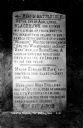
| Date: | 1927 |
|---|---|
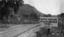
| Description: | View of the Battle Hollow sign along an unpaved road. In the distance on the left is a rock formation covered with trees. Sign reads: "Battle Hollow Clack ... |
| Date: | 1930 |
|---|---|
| Description: | View of the historic site marker on Highway 35 indicating the location of Bad Axe Battlefield. Caption reads: "Tablet on Highway #35 * Victory, Wis." |
If you didn't find the material you searched for, our Library Reference Staff can help.
Call our reference desk at 608-264-6535 or email us at: