Filter: Categories of Wisconsin Historical Images
Filter: County of Trempealeau
Filter: Categories of Wisconsin Historical Images
Filter: County of Trempealeau

| Date: | 1854 |
|---|---|
| Description: | This map is mounted on cloth and shows lot and block numbers, streets, additions, and public squares. Also included is information on Trempealeau, an inset... |
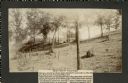
| Date: | 1905 |
|---|---|
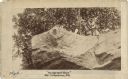
| Description: | Two of a series of three large platform mounds on the top of a high hill, overlooking the Mississippi and Black River valleys. Two young children are seate... |
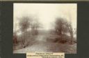
| Date: | 1905 |
|---|---|
| Description: | View across top of platform mound on the crest of a high hill. Trees are on the left and right. In the background below is the Mississippi River. |
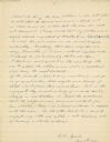
| Date: | 11 04 1921 |
|---|---|
| Description: | The last, signed page of an 11-page manuscript titled "The Platforms at Trempeleau." |

| Date: | 1955 |
|---|---|
| Description: | This blue line print shows streets, fair grounds, schools, parks, and a cemetery. Streets, points of interest, and Lake Marinuka are labeled. The middle le... |
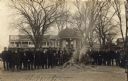
| Date: | 11 11 1918 |
|---|---|
| Description: | Crowd of men and young boys gathered around a smoldering pile of ash and scraps in the Galesville Town Square. The burned items were most likely German boo... |
| Date: | |
|---|---|
| Description: | Drawing, with watercolor added, of a French fort next to a body of water with a large hill in the background. There are canoes at the water's edge. Structu... |
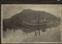
| Date: | 1906 |
|---|---|
| Description: | View across water towards the steamer Quincy, of the Diamond Jo Line, partially sunken into the Mississippi River and listing to port near the shore... |

| Date: | 1920 |
|---|---|
| Description: | This blue print map shows landownership between 1913 and 1916, topography, railroads, and roads. The map covers the vicinity of Perrot State Park. |
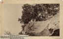
| Date: | 1888 |
|---|---|
| Description: | View looking up at three men and a child on top of a cliff on which are petroglyphs. Caption on photograph reads: "Pictograph Rock. Rock bearing aboriginal... |
| Date: | 1888 |
|---|---|
| Description: | View looking up at three men and a child on top of a cliff on which are petroglyphs. Pictograph Rock bearing aboriginal carvings, located on the south side... |
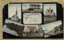
| Date: | 1915 |
|---|---|
| Description: | Six images from Eleva, including two churches, two street scenes, a dwelling and a lake. |

| Date: | 05 30 1981 |
|---|---|
| Description: | U.S. Congressman, Steve Gunderson, milking a cow at an AG Co-Op, the Theron Paulson farm. |
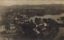
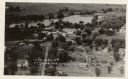
| Date: | |
|---|---|
| Description: | Photographic postcard aerial view of Ettrick. A river is running through town. Dwellings and commercial buildings are surrounded by fields. |
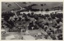
| Date: | |
|---|---|
| Description: | Aerial view of Ettrick. A river and fields are in the background. There is a church in the foreground on the left, and on the main street are commercial bu... |
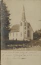
| Date: | |
|---|---|
| Description: | Sepia-toned view of the Presbyterian Church, which is a wooden structure with a large arched window in front and a steeple over the entrance. |
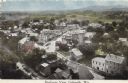
| Date: | |
|---|---|
| Description: | View of the main street and railroad tracks going through Galesville and the surrounding neighborhoods. Fields and hills are in the distance. |
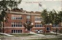
| Date: | 1912 |
|---|---|
| Description: | Hand-colored view of the high school. There is a flag flying from the roof. |
If you didn't find the material you searched for, our Library Reference Staff can help.
Call our reference desk at 608-264-6535 or email us at: