 Filter: Categories of Wisconsin Historical Images
Filter: County of Trempealeau
Filter: Subject of human settlements
Filter: Categories of Wisconsin Historical Images
Filter: County of Trempealeau
Filter: Subject of human settlements
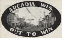
| Date: | 07 29 1909 |
|---|---|
| Description: | View of Main Street. Shops and businesses line both sides of the street including a hotel, city livery and laundromat. There are pedestrians and horse-draw... |
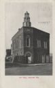
| Date: | 07 1911 |
|---|---|
| Description: | Exterior view of the front entrance on a corner of the two-story brick City Hall. A horse-drawn wagon is visible on the far left. Caption reads: "City Hall... |
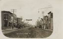
| Date: | 1909 |
|---|---|
| Description: | View looking down Main Street. Shops and businesses line both sides of the street including the P.J. Wossenburger Hotel, city livery, bakery and harness sh... |

| Date: | 10 17 1923 |
|---|---|
| Description: | Exterior view of the two-story brick High School building with basement. A bare flagpole can be seen on the roof. Caption reads: "High School, Arcadia, Wis... |

| Date: | 08 20 1909 |
|---|---|
| Description: | Exterior of the one-story brick Carnegie Library. |
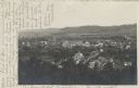
| Date: | 05 22 1906 |
|---|---|
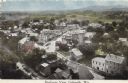
| Description: | Aerial view of the city and rolling hills in the background. A bridge crossing the Trempealeau River is also visible. |

| Date: | 1877 |
|---|---|
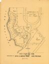
| Description: | This 1877 map of Trempealeau County, Wisconsin, shows the township and range grid, sections, towns, cities and villages, land ownership and acreages, roads... |

| Date: | 1929 |
|---|---|
| Description: | This 1929 topographic map of Trempealeau County, Wisconsin, shows the topography, lakes, streams and wetlands, township and range grid, sections, cities an... |
| Date: | |
|---|---|
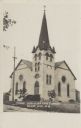
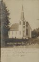
| Description: | Exterior view of a brick church with arched and round windows, and a steeple. |
| Date: | |
|---|---|
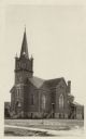
| Description: | An exterior view of a brick church with arched stained glass windows and a steeple. Stairs leading to the front and 2 side entrances. |
| Date: | 1900 |
|---|---|
| Description: | This maps shows part of Galesville, Trempealeau County, Wisconsin. The map shows lots for sale, local streets, and part of Lake Marinuka. Lots are numbered... |
| Date: | 1890 |
|---|---|
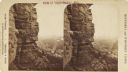
| Description: | Stereograph view from the bluffs looking down over a town. A man is standing on the edge of the side of the formation, about halfway up, above treeline, an... |

| Date: | 1955 |
|---|---|
| Description: | This blue line print shows streets, fair grounds, schools, parks, and a cemetery. Streets, points of interest, and Lake Marinuka are labeled. The middle le... |
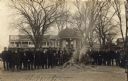
| Date: | 11 11 1918 |
|---|---|
| Description: | Crowd of men and young boys gathered around a smoldering pile of ash and scraps in the Galesville Town Square. The burned items were most likely German boo... |

| Date: | 1920 |
|---|---|
| Description: | This blue print map shows landownership between 1913 and 1916, topography, railroads, and roads. The map covers the vicinity of Perrot State Park. |
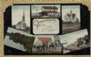
| Date: | 1915 |
|---|---|
| Description: | Six images from Eleva, including two churches, two street scenes, a dwelling and a lake. |
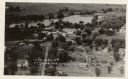
| Date: | |
|---|---|
| Description: | Photographic postcard aerial view of Ettrick. A river is running through town. Dwellings and commercial buildings are surrounded by fields. |
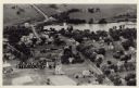
| Date: | |
|---|---|
| Description: | Aerial view of Ettrick. A river and fields are in the background. There is a church in the foreground on the left, and on the main street are commercial bu... |
| Date: | |
|---|---|
| Description: | Sepia-toned view of the Presbyterian Church, which is a wooden structure with a large arched window in front and a steeple over the entrance. |
| Date: | |
|---|---|
| Description: | View of the main street and railroad tracks going through Galesville and the surrounding neighborhoods. Fields and hills are in the distance. |
If you didn't find the material you searched for, our Library Reference Staff can help.
Call our reference desk at 608-264-6535 or email us at: