 Filter: Categories of Wisconsin Historical Images
Filter: County of St. Croix
Filter: Year of 1800-1899
Filter: Categories of Wisconsin Historical Images
Filter: County of St. Croix
Filter: Year of 1800-1899

| Date: | 06 12 1899 |
|---|---|
| Description: | Rear view of a small group of women and children observing the aftermath of a tornado. They are standing on boards, and debris covers the ground. |

| Date: | 06 12 1899 |
|---|---|
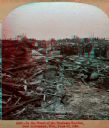
| Description: | Debris left after tornado. A portion of a roof from a collapsed building lies on top of the debris, including the wheels of a carriage or cart. |
| Date: | 06 12 1899 |
|---|---|
| Description: | View of debris, perhaps from tornado damage in the business district of New Richmond. A group of onlookers investigate the damage. Caption on stereograph r... |
| Date: | 1870 |
|---|---|
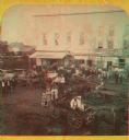
| Description: | Stereograph of New Richmond(?) during a fourth of July celebration. Identification has not been fully verified, but there was a Coombs Hotel in this town a... |
| Date: | 1872 |
|---|---|
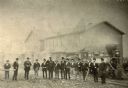
| Description: | Employees of the West Wisconsin Railway stand in a line in front of Engine No. 12. From left to right are E.S. Graves (auditor's office clerk), A.H. Baldwi... |

| Date: | 07 16 1895 |
|---|---|
| Description: | A man stands in ten acres of flowering onion plants, planted for seed, in the Grant Bros. gardens. A horse pulls a buggy in the field in the background. Wo... |
| Date: | 1895 |
|---|---|
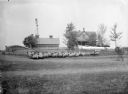
| Description: | A flock of purebred Shropshire ewes standing near a fence on the farm of Geo. Martin. In the background is a farmhouse with laundry on the line, a farm bui... |

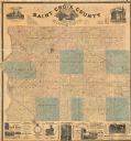
| Date: | 1876 |
|---|---|
| Description: | This 1876 map of Saint Croix County, Wisconsin, shows the township and range grid, sections, towns, cities and villages, land ownership and acreages, wagon... |
| Date: | 1886 |
|---|---|
| Description: | This 1886 map of Saint Croix County, Wisconsin, shows the township and range grid, sections, towns, cities and villages, land ownership and acreages, wagon... |

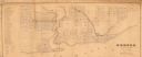
| Date: | 1890 |
|---|---|
| Description: | This late 19th century map shows mining companies' lands and miscellaneous properties in the towns of Cady and Springfield in southeastern Saint Croix Coun... |
| Date: | 1850 |
|---|---|
| Description: | This map shows a plat of city, land ownership by name, local streets, roads, and part of Willow River and Lake St. Croix. The map is indexed by additions a... |
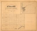
| Date: | 1855 |
|---|---|
| Description: | This map shows McKenty's Addition between Maple Street and Hazel Street, and Spruce Street and Oak Street. The map also features an inset map of Hudson and... |
| Date: | 1873 |
|---|---|
| Description: | This map is pen-and-ink on cloth and shows lot numbers, block letters, streets, West Wis. Railway, Hudson City Mills, and Lake St. Croix. Also included are... |
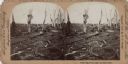
| Date: | 1899 |
|---|---|
| Description: | Stereograph of the devastation caused by a tornado. All that remains of trees are the main branches and trunks, some with building debris caught in them. P... |

| Date: | 1893 |
|---|---|
| Description: | Two unidentified women posing together. The woman on the left is sitting on a table or bench, and is wearing a hat and a coat with a cape. The other woman ... |
If you didn't find the material you searched for, our Library Reference Staff can help.
Call our reference desk at 608-264-6535 or email us at: