 Filter: Categories of Wisconsin Historical Images
Filter: County of St. Croix
Filter: Subject of transportation
Filter: Year of 1800-1899
Filter: Categories of Wisconsin Historical Images
Filter: County of St. Croix
Filter: Subject of transportation
Filter: Year of 1800-1899

| Date: | 1870 |
|---|---|
| Description: | Bird's-eye map of Hudson, with insets of Court House and Public School. |
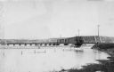
| Date: | 1898 |
|---|---|
| Description: | View along shoreline towards the St. Croix River bridge, with a view of the town in the background. |
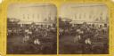
| Date: | 1870 |
|---|---|
| Description: | Stereograph of New Richmond(?) during a fourth of July celebration. Identification has not been fully verified, but there was a Coombs Hotel in this town a... |
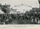
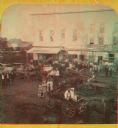
| Date: | 1899 |
|---|---|
| Description: | View of a marching band parading beneath a decorated arch on Main Street. Onlookers line both sides of the street. American flags are flying over the road ... |

| Date: | 06 1899 |
|---|---|
| Description: | Elevated view of New Richmond after the tornado hit on June 12, 1899. Many people are gathered around the railroad tracks and a few others are seen among t... |
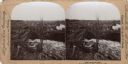
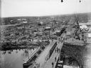
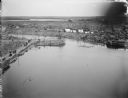
| Date: | 06 12 1899 |
|---|---|
| Description: | Elevated view of a town with a railroad bridge crossing over a river. Several individuals are visible crossing the bridge. Sign near bridge says: "Willow R... |
| Date: | 06 12 1899 |
|---|---|
| Description: | Elevated view toward the horizon over a bridge on a river of the widespread destruction left in the wake of a tornado. Destroyed houses litter the scene an... |
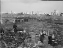
| Date: | 06 12 1899 |
|---|---|
| Description: | A firetruck with its hose hanging into the water is surrounded by debris and other wreckage left from a tornado. |
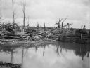
| Date: | 06 12 1899 |
|---|---|
| Description: | Elevated view over water, perhaps Hatfield Lake, of damage to houses and property caused by a tornado. Groups of people are scattered throughout the town. |
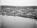
| Date: | 06 12 1899 |
|---|---|
| Description: | View over water, perhaps Hatfield Lake, of houses damaged and demolished in a tornado. Floating at the edge of the lake near an eroded bank are numerous pi... |
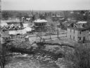
| Date: | 06 12 1899 |
|---|---|
| Description: | Elevated view over water of the damage created by a tornado. A river, with debris visibly floating in it, runs through the town. Groups of people are walki... |
| Date: | 06 12 1899 |
|---|---|
| Description: | Side view of a group of people looking at the debris left by a tornado from a covered horse-drawn carriage. In the foreground the roof of a houselies on th... |
| Date: | 06 12 1899 |
|---|---|
| Description: | Elevated view of people working with the relief effort in the aftermath of a tornado. Boxes of supplies are piled near a man in the foreground, and a man h... |

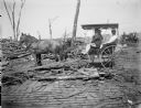
| Date: | 06 12 1899 |
|---|---|
| Description: | Debris left after tornado. A portion of a roof from a collapsed building lies on top of the debris, including the wheels of a carriage or cart. |
| Date: | 1870 |
|---|---|
| Description: | Stereograph of New Richmond(?) during a fourth of July celebration. Identification has not been fully verified, but there was a Coombs Hotel in this town a... |
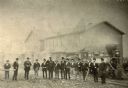
| Date: | 1872 |
|---|---|
| Description: | Employees of the West Wisconsin Railway stand in a line in front of Engine No. 12. From left to right are E.S. Graves (auditor's office clerk), A.H. Baldwi... |

| Date: | 07 16 1895 |
|---|---|
| Description: | A man stands in ten acres of flowering onion plants, planted for seed, in the Grant Bros. gardens. A horse pulls a buggy in the field in the background. Wo... |

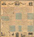
| Date: | 1876 |
|---|---|
| Description: | This 1876 map of Saint Croix County, Wisconsin, shows the township and range grid, sections, towns, cities and villages, land ownership and acreages, wagon... |
| Date: | 1886 |
|---|---|
| Description: | This 1886 map of Saint Croix County, Wisconsin, shows the township and range grid, sections, towns, cities and villages, land ownership and acreages, wagon... |

| Date: | 1890 |
|---|---|
| Description: | This late 19th century map shows mining companies' lands and miscellaneous properties in the towns of Cady and Springfield in southeastern Saint Croix Coun... |
If you didn't find the material you searched for, our Library Reference Staff can help.
Call our reference desk at 608-264-6535 or email us at: