Filter: Categories of Wisconsin Historical Images
Filter: County of St. Croix
Filter: Subject of land
Filter: Categories of Wisconsin Historical Images
Filter: County of St. Croix
Filter: Subject of land

| Date: | 1870 |
|---|---|
| Description: | Bird's-eye map of Hudson, with insets of Court House and Public School. |
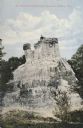
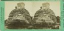
| Date: | 1905 |
|---|---|
| Description: | View of the Kinnickinnic monument with two people posing on top. Caption reads: "The Wonderful Kinnickinnic Monument, Hudson, Wis." |

| Date: | 1910 |
|---|---|
| Description: | View down street in downtown Glenwood, Wisconsin. Caption reads: "First St. Glenwood, Wis." |

| Date: | 1909 |
|---|---|
| Description: | Elevated view of town. Caption reads: "Bird's-Eye View, Glenwood, Wis." |
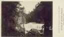
| Date: | 1880 |
|---|---|
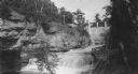
| Description: | Willow River Falls. Text at right reads: "Published by Whitney's Gallery, St. Paul, Minn. Willow River Falls Near Hudeson, Wis." |

| Date: | 1915 |
|---|---|
| Description: | Elevated view of the St. Croix River, Northwest Railroad, bridge, and part of the town of Hudson. Caption reads: "Hudson, Wis. Bird's Eye View, showing St.... |
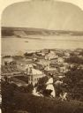
| Date: | 1870 |
|---|---|
| Description: | View of Hudson with three women on a hill in the foreground, and the town along the St. Croix River below in the background. |
| Date: | 1915 |
|---|---|
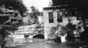
| Description: | Burkhardt Milling and Electric Power Co., built in 1914. |
| Date: | 1915 |
|---|---|
| Description: | Burkhardt Milling and Electric Power Co., built in 1914. |
| Date: | 06 1977 |
|---|---|
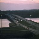
| Description: | A view of the St. Croix River crossing at Hudson during the development of the Interstate Bridge. The old eastbound bridge seen here was built in 1951 whil... |
| Date: | 1900 |
|---|---|
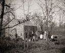
| Description: | Unidentified family standing outside of a cottage in the woods near Baldwin. |

| Date: | 06 1899 |
|---|---|
| Description: | Elevated view of New Richmond after the tornado hit on June 12, 1899. Many people are gathered around the railroad tracks and a few others are seen among t... |
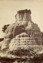
| Date: | |
|---|---|
| Description: | A man, woman, and child stand near or on the Pulpit Rock formation. The man is standing near the top, while the woman and child are near the ground. |

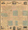
| Date: | 1876 |
|---|---|
| Description: | This 1876 map of Saint Croix County, Wisconsin, shows the township and range grid, sections, towns, cities and villages, land ownership and acreages, wagon... |
| Date: | 1886 |
|---|---|
| Description: | This 1886 map of Saint Croix County, Wisconsin, shows the township and range grid, sections, towns, cities and villages, land ownership and acreages, wagon... |

| Date: | 1890 |
|---|---|
| Description: | This late 19th century map shows mining companies' lands and miscellaneous properties in the towns of Cady and Springfield in southeastern Saint Croix Coun... |

| Date: | 1913 |
|---|---|
| Description: | This early 20th century map of Saint Croix County, Wisconsin, shows the township and range grid, sections, towns, villages, roads, railroads, and lakes and... |

| Date: | 1939 |
|---|---|
| Description: | This 1939 map of Saint Croix County, Wisconsin, shows the township and range grid, cities and villages, and lakes and streams. |
If you didn't find the material you searched for, our Library Reference Staff can help.
Call our reference desk at 608-264-6535 or email us at: