 Filter: Categories of Wisconsin Historical Images
Filter: County of Sheboygan
Filter: Year of 1800-1899
Filter: Year of 1860-1869
Filter: Categories of Wisconsin Historical Images
Filter: County of Sheboygan
Filter: Year of 1800-1899
Filter: Year of 1860-1869
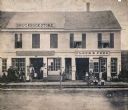
| Date: | 1864 |
|---|---|
| Description: | Street scene with customers in front of the M.P. Roberts Drugstore and C. Baack Flour and Feed Store. |
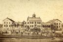
| Date: | 1865 |
|---|---|
| Description: | View of a mission house, erected between 1862 and 1873. |
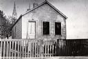
| Date: | 1863 |
|---|---|
| Description: | Exterior view of M. Gottshalk's first meat market. |
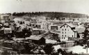
| Date: | 1868 |
|---|---|
| Description: | A view taken from the elevation on the south side of the Mullet River. |
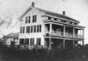
| Date: | 1860 |
|---|---|
| Description: | The oldest known image of the Wade House (taken from Ambrotype) with the Sheboygan/Fond du Lac Plank Road in the foreground. |

| Date: | 1862 |
|---|---|
| Description: | This 1862 map of Sheboygan County, Wisconsin, shows land ownership and acreages, the township and range grid, towns, cities and villages, roads, railroads,... |

| Date: | 1862 |
|---|---|
| Description: | Shows townships and sections, landownership and acreage, roads, railroads, churches, schools, and cemeteries. Inset maps: Plat of Hingham -- Plat of Casca... |

| Date: | 1865 |
|---|---|
| Description: | This map shows the harbor with proposed extensions and the shore line as it appeared in 1865. Depths are shown by soundings. |
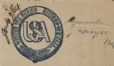
| Date: | 05 25 1864 |
|---|---|
| Description: | Letterhead of a belt looped in a circle around interlocking letters reading: "USA." Text printed on the belt reads: "United We Stand, Divided We Fall." Ill... |
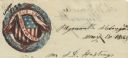
| Date: | 05 18 1863 |
|---|---|
| Description: | Letterhead with a wreath around the American shield. The text behind the shield, partially obscured, reads: "E Pluribus Unum." A banner hanging on the shie... |
If you didn't find the material you searched for, our Library Reference Staff can help.
Call our reference desk at 608-264-6535 or email us at: