 Filter: Categories of Wisconsin Historical Images
Filter: County of Sheboygan
Filter: Subject of transportation
Filter: Year of 1800-1899
Filter: Categories of Wisconsin Historical Images
Filter: County of Sheboygan
Filter: Subject of transportation
Filter: Year of 1800-1899
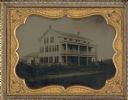
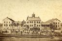
| Date: | 1858 |
|---|---|
| Description: | Ambrotype of the Wade House, a carriage inn located in Greenbush, also showing a section of the original plank road in the foreground. |
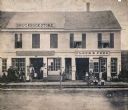
| Date: | 1888 |
|---|---|
| Description: | Exterior view of Charles Pfeifer's Drugstore, founded in 1858. From left to right are Charles Pfeifer, Fred Pfeifer, Mrs. Adam Heeb, Fulda Pfeifer, Mrs. Ch... |
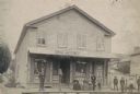
| Date: | 1864 |
|---|---|
| Description: | Street scene with customers in front of the M.P. Roberts Drugstore and C. Baack Flour and Feed Store. |

| Date: | 1885 |
|---|---|
| Description: | Bird's-eye view of Sheboygan, with inset of J.J. Volrath Manufacturing Company. |
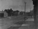
| Date: | 1890 |
|---|---|
| Description: | Slightly elevated view across street towards a residential area. |

| Date: | 1871 |
|---|---|
| Description: | Elevated view of South Twelfth Street. There is a child standing in the center of the street holding onto a wagon in which another child is sitting. A chur... |

| Date: | 1890 |
|---|---|
| Description: | View from road towards a mission house, erected between 1862 and 1873. |
| Date: | 1865 |
|---|---|
| Description: | View of a mission house, erected between 1862 and 1873. |
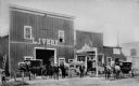
| Date: | 1892 |
|---|---|
| Description: | Men posed in front of a livery barn and horse sales stable. |

| Date: | 1857 |
|---|---|
| Description: | This map of Sheboygan Harbor shows the river mouth and harbor, piers, wharfs, piles of old destroyed bridge wharfs, streets, and the lake shore from survey... |

| Date: | 1836 |
|---|---|
| Description: | This 1836 map consists chiefly of a detailed map of the the mouth of the Sheboygan River. An inset map of the region and cross section diagrams of the pier... |

| Date: | 1862 |
|---|---|
| Description: | This 1862 map of Sheboygan County, Wisconsin, shows land ownership and acreages, the township and range grid, towns, cities and villages, roads, railroads,... |

| Date: | 1898 |
|---|---|
| Description: | This map shows the contour depths of Elkhart Lake in the Town of Rhine, Sheboygan County, Wisconsin, and includes two cross sections of the lake. The villa... |
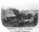
| Date: | 1878 |
|---|---|
| Description: | Elevated view of several buildings making up the Sheboygan Falls Tannery, which was owned by proprietor C.S. Weisse. Weisse is at the far right, standing w... |

| Date: | 1862 |
|---|---|
| Description: | Shows townships and sections, landownership and acreage, roads, railroads, churches, schools, and cemeteries. Inset maps: Plat of Hingham -- Plat of Casca... |

| Date: | 1840 |
|---|---|
| Description: | This is a plat map of Sheboygan showing the Sheboygan River and Lake Michigan. Streets are labeled and plats are numbered in quadrants. Some points of inte... |
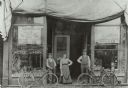
| Date: | 06 1899 |
|---|---|
| Description: | Two men and a woman pose on a wooden sidewalk in front of a bicycle livery with three bicycles. An awning is folded above the storefront, and signs and mer... |

| Date: | 1893 |
|---|---|
| Description: | This map shows wards, railroads, street cars, streets, lot and block numbers, landownership, parks, hospitals, the Sheboygan River, and Lake Michigan. Ward... |
If you didn't find the material you searched for, our Library Reference Staff can help.
Call our reference desk at 608-264-6535 or email us at:

