 Filter: Categories of Wisconsin Historical Images
Filter: County of Sheboygan
Filter: Subject of transportation
Filter: Categories of Wisconsin Historical Images
Filter: County of Sheboygan
Filter: Subject of transportation

| Date: | 08 23 1925 |
|---|---|
| Description: | Two men stand in front of the wooden Central Hotel building while a third stands in the doorway. An automobile is parked in front. To the right is a second... |

| Date: | |
|---|---|
| Description: | Reiss Oil Company yard, with large tank, at the end of East Water Street. |

| Date: | 08 14 2009 |
|---|---|
| Description: | We visit Chissy's Pub And Grille, 501 North Mill Street, (just odd Highway 57) Waldo." From left to right, John P. Widmer, Ralph "Buddy" Ruecker, and Shirl... |

| Date: | 1932 |
|---|---|
| Description: | Hand-colored photograph of students from Liberty school, a one-room school in Sheboygan County. The children in the back row are standing on the bumper of ... |
| Date: | |
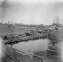
|---|---|
| Description: | View from roof of wagons lined up by the Herrling sawmill. |
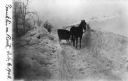
| Date: | 02 06 1908 |
|---|---|
| Description: | The horse-drawn mail delivery sleigh used by Franklin Herrling. |
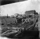
| Date: | 1903 |
|---|---|
| Description: | Rudolf Herrling farm looking west from the sawmill platform. Three men are near horses and carts in a fenced-in area. In the background is the farmhouse. |

| Date: | 1857 |
|---|---|
| Description: | This map of Sheboygan Harbor shows the river mouth and harbor, piers, wharfs, piles of old destroyed bridge wharfs, streets, and the lake shore from survey... |
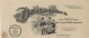
| Date: | |
|---|---|
| Description: | Letterhead of The Dutch Canning Company of Cedar Grove, Wisconsin, "Packers of Fancy Corn Peas and Beans," with a boy and girl in traditional clothing and ... |
| Date: | 1941 |
|---|---|
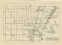
| Description: | A map shows early settlers by name and date, industries, the Chicago & North Western rail line, roads, and depths and net lines in Lake Michigan. Text prov... |

| Date: | 1836 |
|---|---|
| Description: | This 1836 map consists chiefly of a detailed map of the the mouth of the Sheboygan River. An inset map of the region and cross section diagrams of the pier... |

| Date: | 1862 |
|---|---|
| Description: | This 1862 map of Sheboygan County, Wisconsin, shows land ownership and acreages, the township and range grid, towns, cities and villages, roads, railroads,... |

| Date: | 1934 |
|---|---|
| Description: | This 1930s highway map of Sheboygan County, Wisconsin, shows roads, the township and range grid, towns, sections, cities and villages, and streams, lakes, ... |

| Date: | 1906 |
|---|---|
| Description: | This map of Sheboygan County, Wisconsin, from the early 20th century shows school districts and school locations in the county. Also shown are the township... |

| Date: | 1972 |
|---|---|
| Description: | This map of Sheboygan County, Wisconsin, shows the location of churches in the county. Churches are indexed for each town. Also shown are sections, cities ... |
| Date: | |
|---|---|
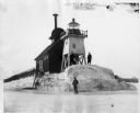
| Description: | Three men pose standing on ice around North Pier lighthouse. In the background is the town along the shoreline. |

| Date: | 1898 |
|---|---|
| Description: | This map shows the contour depths of Elkhart Lake in the Town of Rhine, Sheboygan County, Wisconsin, and includes two cross sections of the lake. The villa... |
| Date: | 1878 |
|---|---|
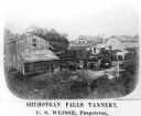
| Description: | Elevated view of several buildings making up the Sheboygan Falls Tannery, which was owned by proprietor C.S. Weisse. Weisse is at the far right, standing w... |

| Date: | 1862 |
|---|---|
| Description: | Shows townships and sections, landownership and acreage, roads, railroads, churches, schools, and cemeteries. Inset maps: Plat of Hingham -- Plat of Casca... |
If you didn't find the material you searched for, our Library Reference Staff can help.
Call our reference desk at 608-264-6535 or email us at:
