 Filter: Categories of Wisconsin Historical Images
Filter: County of Sheboygan
Filter: Subject of human settlements
Filter: Categories of Wisconsin Historical Images
Filter: County of Sheboygan
Filter: Subject of human settlements

| Date: | 1977 |
|---|---|
| Description: | This 1977 map identifies the locations of 100 cemeteries in Sheboygan County, Wisconsin. Cemeteries are listed by town. |

| Date: | 1836 |
|---|---|
| Description: | This 1836 map consists chiefly of a detailed map of the the mouth of the Sheboygan River. An inset map of the region and cross section diagrams of the pier... |

| Date: | 1862 |
|---|---|
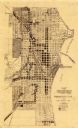
| Description: | This 1862 map of Sheboygan County, Wisconsin, shows land ownership and acreages, the township and range grid, towns, cities and villages, roads, railroads,... |

| Date: | 1934 |
|---|---|
| Description: | This 1930s highway map of Sheboygan County, Wisconsin, shows roads, the township and range grid, towns, sections, cities and villages, and streams, lakes, ... |

| Date: | 1906 |
|---|---|
| Description: | This map of Sheboygan County, Wisconsin, from the early 20th century shows school districts and school locations in the county. Also shown are the township... |

| Date: | 1972 |
|---|---|
| Description: | This map of Sheboygan County, Wisconsin, shows the location of churches in the county. Churches are indexed for each town. Also shown are sections, cities ... |
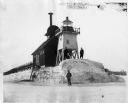
| Date: | |
|---|---|
| Description: | Three men pose standing on ice around North Pier lighthouse. In the background is the town along the shoreline. |

| Date: | 1898 |
|---|---|
| Description: | This map shows the contour depths of Elkhart Lake in the Town of Rhine, Sheboygan County, Wisconsin, and includes two cross sections of the lake. The villa... |
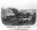
| Date: | 1878 |
|---|---|
| Description: | Elevated view of several buildings making up the Sheboygan Falls Tannery, which was owned by proprietor C.S. Weisse. Weisse is at the far right, standing w... |

| Date: | 1862 |
|---|---|
| Description: | Shows townships and sections, landownership and acreage, roads, railroads, churches, schools, and cemeteries. Inset maps: Plat of Hingham -- Plat of Casca... |
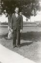
| Date: | 1931 |
|---|---|
| Description: | Kermit Schulz poses in front of a pine tree wearing a three piece suit. He is the teacher at Rhine Center School, District No. 6. |
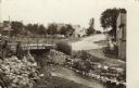
| Date: | 1908 |
|---|---|
| Description: | View of a street going through the center of town. In the foreground is a stream and a bridge. Commercial buildings and dwellings are on the left. |

| Date: | 1921 |
|---|---|
| Description: | This map is part of the survey of the northern and northwestern lakes. The map shows Sheboygan Harbor on the shore of Lake Michigan and the Sheboygan River... |
| Date: | 1935 |
|---|---|
| Description: | This map created by the Sheboygan City Engineer department shows five different types of land use in the city in 1935. A legend in the bottom right corner ... |

| Date: | 1840 |
|---|---|
| Description: | This is a plat map of Sheboygan showing the Sheboygan River and Lake Michigan. Streets are labeled and plats are numbered in quadrants. Some points of inte... |

| Date: | 06 1899 |
|---|---|
| Description: | Two men and a woman pose on a wooden sidewalk in front of a bicycle livery with three bicycles. An awning is folded above the storefront, and signs and mer... |
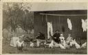
| Date: | |
|---|---|
| Description: | A smiling grandfather has his arm around a toddler granddaughter. A toddler boy is standing next to them. They are surrounded by chickens, and behind them ... |
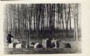
| Date: | |
|---|---|
| Description: | Behind a barbed wire fence a man is splitting log rounds into barrel staves. The staves are stacked neatly to dry. |
| Date: | 1900 |
|---|---|
| Description: | An unidentified woman standing near a shed is feeding chickens and geese in the barnyard. |
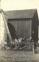
| Date: | |
|---|---|
| Description: | View across barnyard towards five men on the William Fiebelkorn farm working with a wagon and conveyor belt to load hay into a silo. The barn has a stone f... |
If you didn't find the material you searched for, our Library Reference Staff can help.
Call our reference desk at 608-264-6535 or email us at: