 Filter: Categories of Wisconsin Historical Images
Filter: County of Shawano
Filter: Subject of human settlements
Filter: Subject of transportation
Filter: Categories of Wisconsin Historical Images
Filter: County of Shawano
Filter: Subject of human settlements
Filter: Subject of transportation
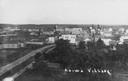
| Date: | 1910 |
|---|---|
| Description: | Elevated view of Aniwa. "Aniwa Village" is written on the photograph. |
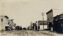
| Date: | 1915 |
|---|---|
| Description: | View down center of unpaved street. Caption reads: "Main St., Bowler Wis". |
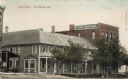
| Date: | 1908 |
|---|---|
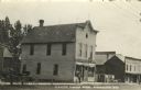
| Description: | The Rand House in Wittenberg. Caption reads: "Rand House, Wittenberg, Wis." |

| Date: | 1930 |
|---|---|
| Description: | Shawano County Highway Department garage. |

| Date: | 1910 |
|---|---|
| Description: | View down center of unpaved street. A sign on the building on the left corner reads: "The Upham & Russell Co. Hardware and Metals". A barber's pole is on t... |
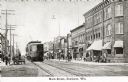
| Date: | 1912 |
|---|---|
| Description: | View down street, with a trolley coming up the left side. Pedestrians are on the sidewalks. Caption reads: "Main Street, Shawano, Wis." |

| Date: | 1910 |
|---|---|
| Description: | View down center of unpaved street. Caption reads: "Main St., Looking South, Shawano, Wis." |

| Date: | |
|---|---|
| Description: | Stacks of logs are in the foreground with a man in a hat near the river. There is a chimney billowing smoke near the factory. |

| Date: | |
|---|---|
| Description: | Photographic postcard of the Aniwa Mercantile Company building (1903), housing Block and Krom's Store. A horse-drawn cart is parked in front of the store a... |

| Date: | |
|---|---|
| Description: | Photographic postcard view of the Hotel Carley. Two women are sitting on the far left steps of the hotel. One man is sitting in a chair near the entrance, ... |

| Date: | 1920 |
|---|---|
| Description: | This map shows the township and range system, sections, schools, churches, cemeteries, town halls, roads, railroads, and lakes and streams in Shawano Count... |

| Date: | 1933 |
|---|---|
| Description: | This map shows the township and range system, sections, cities and villages, schools, roads, railroads, and lakes and streams in Shawano County, which at t... |

| Date: | 1900 |
|---|---|
| Description: | Shows lands belonging to Wisconsin Timber and Land Co., towns, post offices, saw mills, creameries, camps, churches, schools, farm houses, town halls, rail... |

| Date: | 1909 |
|---|---|
| Description: | Colorized postcard view down center of unpaved street in the central business district of a small town. A group of people are gathered in front of the shop... |
| Date: | 1907 |
|---|---|
| Description: | Photographic postcard view across street towards the Herman Smith Saloon storefront, with a man and two dogs on the sidewalk in front. A horse and buggy ar... |

| Date: | |
|---|---|
| Description: | Photographic postcard of an exterior view from street of a hotel on a snowy day. Caption reads: "Birnamwood, Wis." |
| Date: | |
|---|---|
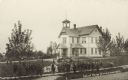
| Description: | Slightly elevated view of a school with the students gathered on the board sidewalk. Adults are gathered near the front steps of the entrance to the school... |
| Date: | |
|---|---|
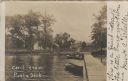
| Description: | Photographic postcard from the end of the public dock looking inland towards buildings on the shoreline. Caption reads: "Cecil from Public Dock." |
| Date: | 1961 |
|---|---|
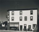
| Description: | Exterior of a hotel, with bright metal siding in full sunlight. An elderly man is seated in a chair outside. Behind the hotel on the left is what appears t... |

| Date: | 1834 |
|---|---|
| Description: | This map is pen, ink, and pencil on paper and shows plat of the town, local streets, mills, forts, hospitals, and parts of Devil River and Fox River. |
If you didn't find the material you searched for, our Library Reference Staff can help.
Call our reference desk at 608-264-6535 or email us at: