 Filter: Categories of Wisconsin Historical Images
Filter: County of Sawyer
Filter: Year of 1900-1999
Filter: Categories of Wisconsin Historical Images
Filter: County of Sawyer
Filter: Year of 1900-1999

| Date: | 1970 |
|---|---|
| Description: | This map shows lot and block numbers, city limits, cemeteries, schools, outdoor theater, Lumberjack Bowl, and Historyland among other attractions. |
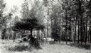
| Date: | 1932 |
|---|---|
| Description: | An early view of the Ojibwa Roadside Park. There are several automobiles in the background, and people sit on benches under the trees. |
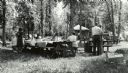
| Date: | 1940 |
|---|---|
| Description: | A group of people having a picnic at the Ojibwa Roadside Park. There are several cars and trucks in the background, and a small building. The picnic tables... |
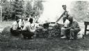
| Date: | 1932 |
|---|---|
| Description: | A group of six men and three women are cooking over a smoky campfire at the Ojibwa Roadside Park. |
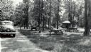
| Date: | 1940 |
|---|---|
| Description: | Several small groups of people are scattered about the roadside park among picnic tables. There are parked automobiles, and a small building. |

| Date: | 1940 |
|---|---|
| Description: | Man standing near a tree stump in the Ojibwa Roadside Park. Two automobiles are parked in the background. The verso of the photograph reads: "Custodian Whi... |
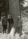
| Date: | 11 17 1949 |
|---|---|
| Description: | Three men, Breuer, Kielcheski, and Harrington, are standing in front of a large white pine in a snow field. The Flambeau River State Forest is located in p... |
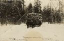
| Date: | 1916 |
|---|---|
| Description: | Black and white photographic postcard of a horse-drawn sled loaded with logs coming out of the woods. One or two men are driving the sled, and a man is wal... |

| Date: | 1911 |
|---|---|
| Description: | This map shows lakes, rivers, swamps, state swamp land, trails and railroads. Includes a township diagram. |

| Date: | 1975 |
|---|---|
| Description: | This map shows boundaries, roads, national forest land, bogs and wetlands, lakes, campgrounds, and boat landings. |

| Date: | 1910 |
|---|---|
| Description: | This blue print map shows original lakes, area to be covered by Chippewa Flowage (flow-lines for contours 1310 and 1315), dam sites, roads, and buildings. |
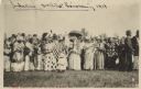
| Date: | 06 19 1919 |
|---|---|
| Description: | A gathering of Native American women, some holding flags, to welcome home soldiers returning from WWI on Corpus Christi Day. There are men in the backgroun... |

| Date: | 1940 |
|---|---|
| Description: | This blue line print map traced from aerial survey mosaic shows reservation boundary, roads, trails, and railroads. Color manuscript annotations show triba... |
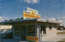
| Date: | 1967 |
|---|---|
| Description: | Exterior view of a small information center. Text on reverse reads: "Keehner's Information Center Specialists in locating you 'A Vacation Spot Sure To ... |

| Date: | 1958 |
|---|---|
| Description: | View down Main Street with businesses on both sides, including drug stores, grocery stores, appliance stores and an insurance/real estate office. Automobil... |
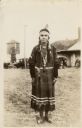
| Date: | 1934 |
|---|---|
| Description: | Full-length portrait of a Native American Woman (Ojibwa) wearing traditional dress. Caption reads: "Chippewa Indian Squaw, Hayward, Wis." |
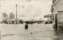
| Date: | 08 29 1941 |
|---|---|
| Description: | View of a flooded road with a truck and cars making their way through. Men are standing knee-deep in the water. A Standard Oil Station is on the left. Ther... |
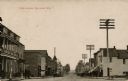
| Date: | 1910 |
|---|---|
| Description: | View down a commercial street lined with businesses. A barber pole is on the left, and a fire hydrant is on the right street corner. Large power poles are ... |

| Date: | 1967 |
|---|---|
| Description: | Aerial view of a lake with islands surrounded by forest. Text on reverse reads: "Joined by a navigable water channel to Lost Land Lake this combined wat... |
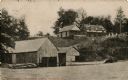
| Date: | 1911 |
|---|---|
| Description: | View across water towards a resort, guest cottage and boathouse. Women are standing behind a fence on the lawn on the hill above on the right. |
If you didn't find the material you searched for, our Library Reference Staff can help.
Call our reference desk at 608-264-6535 or email us at: