Filter: Categories of Wisconsin Historical Images
Filter: County of Sawyer
Filter: Subject of water
Filter: Creator Name of Unknown
Filter: Categories of Wisconsin Historical Images
Filter: County of Sawyer
Filter: Subject of water
Filter: Creator Name of Unknown
| Date: | 1919 |
|---|---|
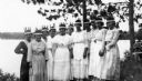
| Description: | A group of Chippewa (Ojibwa) girls in white western clothing and paper feathered headdresses for a celebration commemorating the return of 80 Native Americ... |
| Date: | 1955 |
|---|---|
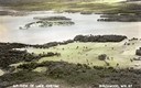
| Description: | Aerial view of Treeland Pines resort on Lake Chippewa. Caption reads: "Air View of Bob Cammack's Treeland Pines Resort; Lake Chippewa, Hayward, Wis." |
| Date: | 1955 |
|---|---|
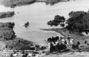
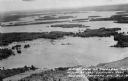
| Description: | Aerial view of Treeland Pines Resort on Lake Chippewa. Caption reads: "Aerial View of Treeland Pines Resort on Lake Chippewa (The Flowage), Hayward, Wis." |
| Date: | 1935 |
|---|---|
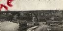
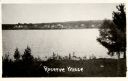
| Description: | View from shoreline towards a village across a body of water. Caption reads: "Reserve Village". |
| Date: | 05 05 1911 |
|---|---|
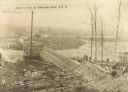
| Description: | Elevated view of construction on Arpin's dam. Men are working on the right. Caption reads: "Arpin's Dam at Radisson, Wis". |
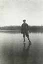
| Date: | |
|---|---|
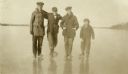
| Description: | Ice skaters posing in a row on a frozen lake (possibly Big Chetac Lake). On the far right is Thomas Oliver Mattis and next to him is (probably) George Matt... |
| Date: | 1922 |
|---|---|
| Description: | A young man, probably George Mattis, Jr., posing wearing ice skates on a frozen lake (possibly Knuteson Lake). |
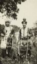
| Date: | 1932 |
|---|---|
| Description: | Outdoor portrait of Peter Wolfe, chief of Lac Courte d'Oreilles band of Ojibwa (Chippewa) Indians, with his son William Wolfe, who was Secretary of Lac Cou... |

| Date: | 1900 |
|---|---|
| Description: | Perspective drawing of the buildings at the Hayward Indian School. There is a man in a boat in the right foreground and an empty boat in the left foregroun... |
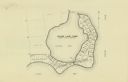
| Date: | |
|---|---|
| Description: | This map shows the lots surrounding Hinton Bay on Round Lake in the Town of Hayward, Sawyer County, Wisconsin. |

| Date: | 1897 |
|---|---|
| Description: | This 1897 map of Sawyer County, Wisconsin, shows the township and range system, sections, roads, farm houses, camps, school houses, dams, bridges, Indian r... |

| Date: | 1898 |
|---|---|
| Description: | This 1898 map of Sawyer County, Wisconsin, shows the township and range system, sections, roads, farm houses, camps, school houses, dams, bridges, Indian r... |

| Date: | 1900 |
|---|---|
| Description: | This map of Sawyer County, Wisconsin, shows the numbered "sub-school-districts of the town of Hayward" school houses, and the Indian reservation. The towns... |

| Date: | 1902 |
|---|---|
| Description: | This 1902 map of the eastern portion of Sawyer County, Wisconsin, shows the township and range system, sections, roads, farm houses, camps, school houses, ... |

| Date: | |
|---|---|
| Description: | This map shows the township and range system, sections, dam locations, railroads, roads, selected buildings, and lakes and streams in Sawyer County, Wiscon... |

| Date: | 1970 |
|---|---|
| Description: | This map shows lot and block numbers, city limits, cemeteries, schools, outdoor theater, Lumberjack Bowl, and Historyland among other attractions. |

| Date: | 1910 |
|---|---|
| Description: | This blue print map shows original lakes, area to be covered by Chippewa Flowage (flow-lines for contours 1310 and 1315), dam sites, roads, and buildings. |
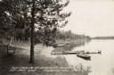
| Date: | 1944 |
|---|---|
| Description: | View along shoreline towards a bench near a tree on the left, and rowboats tied to a dock on the right. Further down the shoreline are a row of rowboats pu... |
If you didn't find the material you searched for, our Library Reference Staff can help.
Call our reference desk at 608-264-6535 or email us at: