 Filter: Categories of Wisconsin Historical Images
Filter: County of Sawyer
Filter: Subject of transportation
Filter: Categories of Wisconsin Historical Images
Filter: County of Sawyer
Filter: Subject of transportation

| Date: | 1911 |
|---|---|
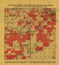
| Description: | This 1911 map of south central Sawyer County, Wisconsin, shows land for sale by Veness & Kasl of Exeland, the township and range system, sections, homes, r... |

| Date: | 1919 |
|---|---|
| Description: | This 1919 map of Sawyer County, Wisconsin, shows the township and range system, sections, cities and villages, roads, railroads, farm houses, the Indian re... |

| Date: | 1925 |
|---|---|
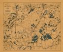
| Description: | This 1925 map of the northern portion of Sawyer County, Wisconsin, shows the township and range system, sections, roads, railroads, and lakes and streams i... |

| Date: | 1926 |
|---|---|
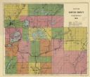
| Description: | This 1926 map of Sawyer County, Wisconsin, the township and range system, towns, sections, cities and villages, railroads, highways and roads, and lakes an... |

| Date: | 1927 |
|---|---|
| Description: | This 1927 map of Sawyer County, Wisconsin, shows the township and range system, sections, cities and villages, roads, railroads, and lakes and streams. |
| Date: | 1931 |
|---|---|
| Description: | This 1931 map of Sawyer County, Wisconsin, shows the township and range system, towns, sections, cities and villages, railroads, highways and roads, and la... |
| Date: | 1940 |
|---|---|
| Description: | This map shows cities and villages, roads, railroads, and lakes and streams in northern Sawyer, northeastern Washburn, southeastern Douglas, and southern B... |

| Date: | 1949 |
|---|---|
| Description: | This 1949 tourism brochure for the Hayward region includes a directory of members of the Hayward Lakes Resort Association, color illustrations, descriptive... |

| Date: | |
|---|---|
| Description: | This map shows the township and range system, sections, dam locations, railroads, roads, selected buildings, and lakes and streams in Sawyer County, Wiscon... |
| Date: | 1920 |
|---|---|
| Description: | This early-20th century map of the towns of Round Lake and Spider Lake, Sawyer County, Wisconsin, shows sections, roads, lake and streams, and land owned a... |

| Date: | 1915 |
|---|---|
| Description: | This map shows a plat of city, wards, sections, land ownership by name, local streets, roads, railroads, local businesses, schools, and parks. This map is ... |

| Date: | 1970 |
|---|---|
| Description: | This map shows lot and block numbers, city limits, cemeteries, schools, outdoor theater, Lumberjack Bowl, and Historyland among other attractions. |
| Date: | 1932 |
|---|---|
| Description: | An early view of the Ojibwa Roadside Park. There are several automobiles in the background, and people sit on benches under the trees. |
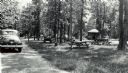
| Date: | 1940 |
|---|---|
| Description: | A group of people having a picnic at the Ojibwa Roadside Park. There are several cars and trucks in the background, and a small building. The picnic tables... |
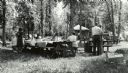
| Date: | 1940 |
|---|---|
| Description: | Several small groups of people are scattered about the roadside park among picnic tables. There are parked automobiles, and a small building. |

| Date: | 1940 |
|---|---|
| Description: | Man standing near a tree stump in the Ojibwa Roadside Park. Two automobiles are parked in the background. The verso of the photograph reads: "Custodian Whi... |
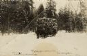
| Date: | 1916 |
|---|---|
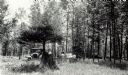
| Description: | Black and white photographic postcard of a horse-drawn sled loaded with logs coming out of the woods. One or two men are driving the sled, and a man is wal... |

| Date: | 1911 |
|---|---|
| Description: | This map shows lakes, rivers, swamps, state swamp land, trails and railroads. Includes a township diagram. |

| Date: | 1910 |
|---|---|
| Description: | This blue print map shows original lakes, area to be covered by Chippewa Flowage (flow-lines for contours 1310 and 1315), dam sites, roads, and buildings. |

| Date: | 1940 |
|---|---|
| Description: | This blue line print map traced from aerial survey mosaic shows reservation boundary, roads, trails, and railroads. Color manuscript annotations show triba... |
If you didn't find the material you searched for, our Library Reference Staff can help.
Call our reference desk at 608-264-6535 or email us at: