 Filter: Categories of Wisconsin Historical Images
Filter: County of Sauk
Filter: Year of 1800-1899
Filter: Year of 1850-1859
Filter: Categories of Wisconsin Historical Images
Filter: County of Sauk
Filter: Year of 1800-1899
Filter: Year of 1850-1859

| Date: | 1859 |
|---|---|
| Description: | Map featuring various views of buildings and scenes from Sauk County. |
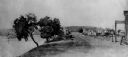
| Date: | 1850 |
|---|---|
| Description: | Buildings along Wisconsin River. |
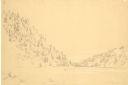
| Date: | 1852 |
|---|---|
| Description: | Devil's Lake from shore flanked by steep tree-covered hillsides. A small solitary rowboat floats near the distant shore. |

| Date: | 01 01 1852 |
|---|---|
| Description: | These manuscript maps, drawn by William H. Canfield in 1852, illustrate mounds primarily in Sauk County, Wisconsin, in the towns of Greenfield, La Valle, M... |

| Date: | 1859 |
|---|---|
| Description: | Shows townships and sections, landownership, roads, railroads, rural residences, schools, churches, and topography. Relief shown by hachures. "From governm... |
If you didn't find the material you searched for, our Library Reference Staff can help.
Call our reference desk at 608-264-6535 or email us at: