 Filter: Categories of Wisconsin Historical Images
Filter: County of Sauk
Filter: Year of 1800-1899
Filter: Categories of Wisconsin Historical Images
Filter: County of Sauk
Filter: Year of 1800-1899

| Date: | 1885 |
|---|---|
| Description: | Elevated view over water towards an elderly man using a long pole to fish from a steep rock ledge on the opposite shoreline. |

| Date: | 07 1870 |
|---|---|
| Description: | This map of Ironton is pen-and-ink on paper and shows lots and block numbers, mill, foundry buildings, limestone quarry, iron mine, and roads. Relief is sh... |

| Date: | 07 1892 |
|---|---|
| Description: | Engraved illustration depicting Frank Lenz sitting on the edge of a railroad bridge holding his safety bicycle in front of him and his box camera on his ba... |

| Date: | 1861 |
|---|---|
| Description: | This map shows townships and sections, landownership, roads, railroads, rural residences, schools, churches, and topography. Also included are inset maps o... |
| Date: | 1898 |
|---|---|
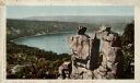
| Description: | Colorized postcard of an elevated view of the Devil's Doorway rock formation at Devil's Lake State Park. Devil's Lake is below in the background. Caption r... |
| Date: | 1870 |
|---|---|
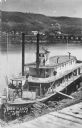
| Description: | Elevated view of the steamer Ellen Hardy at dock. Text on the bottom left reads: "'Ellen Hardy' at Pr-Du-Sac. in 1870." The Ellen Hardy belo... |
| Date: | 1897 |
|---|---|
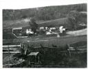
| Description: | View down hill towards a farm in a valley, with wooded bluffs in the background. In the foreground, a fence is at the top of the hill overlooking the farm.... |
| Date: | 1846 |
|---|---|
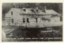
| Description: | A wooden building enclosed by a fence. Caption on rear of photograph reads: First Church In Sauk-Prairie-Roxbury Region - 1846. Reproduction of an early ph... |
| Date: | 1868 |
|---|---|
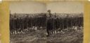
| Description: | Stereograph of an elevated view of hop harvesters, men, women and children, posing in a field at H.H. Potter's Hop Yard. Trellises of mature hops plants ar... |

| Date: | 1896 |
|---|---|
| Description: | View along shoreline of the Wisconsin River, with a sandy beach leading to a stand of trees on the bank on the right. Buildings are along the opposite bank... |

| Date: | 1870 |
|---|---|
| Description: | A stereograph of a bearded man, seen in profile, and a woman, looking directly at the camera, posing near a picket fence. There is a small wood frame house... |

| Date: | 1892 |
|---|---|
| Description: | A Sanborn fire insurance map of Sauk City which was drawn up in 1892. |
If you didn't find the material you searched for, our Library Reference Staff can help.
Call our reference desk at 608-264-6535 or email us at: