 Filter: Categories of Wisconsin Historical Images
Filter: County of Sauk
Filter: Subject of water
Filter: Subject of mines and mineral resources
Filter: Categories of Wisconsin Historical Images
Filter: County of Sauk
Filter: Subject of water
Filter: Subject of mines and mineral resources
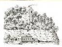
| Date: | 1836 |
|---|---|
| Description: | The shot tower at Tower Hill State Park. |
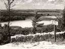
| Date: | 1950 |
|---|---|
| Description: | A view from a bluff on Tower HIll overlooking the Wisconsin River. A sign on the right reads: "Shot Shaft". |
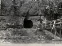
| Date: | 1950 |
|---|---|
| Description: | View across river towards the tunnel leading to the bottom of the shot tower shaft at Tower Hill State Park. There is a rustic bridge on the right leading ... |
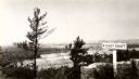
| Date: | 1945 |
|---|---|
| Description: | View from the bluff at Tower Hill State Park of the Wisconsin River. A sign on the right reads: "Tower Hill State Park Shot Shaft". |

| Date: | 12 1903 |
|---|---|
| Description: | This manuscript blueprint map shows streets and lots and includes certifications in the left margin. Horizontal streets top to bottom are: Iroquois, Main, ... |

| Date: | 1903 |
|---|---|
| Description: | This blue line print shows quartzite areas, mines, railroads, and roads. The map covers townships 11-13 north, ranges 4-8 east, in parts of Sauk and Columb... |
If you didn't find the material you searched for, our Library Reference Staff can help.
Call our reference desk at 608-264-6535 or email us at:
