 Filter: Categories of Wisconsin Historical Images
Filter: County of Sauk
Filter: Subject of streams
Filter: Subject of roads
Filter: Categories of Wisconsin Historical Images
Filter: County of Sauk
Filter: Subject of streams
Filter: Subject of roads

| Date: | 1926 |
|---|---|
| Description: | Map showing Devil's Lake State Park limits, railroads, roads, creeks, trails, and park sites. Accompanying text about the location, natural features, attra... |

| Date: | 1915 |
|---|---|
| Description: | This 1915 map covers the section of the Wisconsin River in southern Adams, southeastern Juneau, northeastern Sauk, and northwestern Columbia counties. A po... |
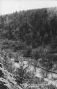
| Date: | 1950 |
|---|---|
| Description: | Text on front reads: "The Old Mill Stream in the Narrows at Rock Springs, Wis." A road and the Narrows Creek run next to each other in an elevated view of ... |

| Date: | 11 04 1912 |
|---|---|
| Description: | A horse-drawn buggy crossing a bridge with trees overhead. |
If you didn't find the material you searched for, our Library Reference Staff can help.
Call our reference desk at 608-264-6535 or email us at: