 Filter: Categories of Wisconsin Historical Images
Filter: County of Sauk
Filter: Subject of roads
Filter: Subject of school buildings
Filter: Categories of Wisconsin Historical Images
Filter: County of Sauk
Filter: Subject of roads
Filter: Subject of school buildings

| Date: | 1870 |
|---|---|
| Description: | Baraboo was first settled around 1838, and by 1870 it had become the county seat and the thriving village illustrated here. This birds eye drawing depicts ... |
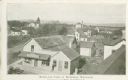
| Date: | 1900 |
|---|---|
| Description: | Elevated view of commercial buildings, houses, a church and a school in a neighborhood. In the foreground a person is standing at the side of a building wi... |

| Date: | 1915 |
|---|---|
| Description: | This 1915 map covers the section of the Wisconsin River in southern Adams, southeastern Juneau, northeastern Sauk, and northwestern Columbia counties. A po... |

| Date: | 1859 |
|---|---|
| Description: | Shows townships and sections, landownership, roads, railroads, rural residences, schools, churches, and topography. Relief shown by hachures. "From governm... |
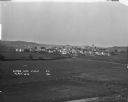
| Date: | 1921 |
|---|---|
| Description: | Elevated view over farm fields in the foreground and town in the distance, with low rolling hills in the far background. Buildings that stand out are St Lu... |
If you didn't find the material you searched for, our Library Reference Staff can help.
Call our reference desk at 608-264-6535 or email us at: