 Filter: Categories of Wisconsin Historical Images
Filter: County of Sauk
Filter: Subject of railroads
Filter: Year of 1800-1899
Filter: Categories of Wisconsin Historical Images
Filter: County of Sauk
Filter: Subject of railroads
Filter: Year of 1800-1899

| Date: | 1883 |
|---|---|
| Description: | Bird's-eye map of Prairie du Sac, Wisconsin with an inset of Clifton. |
| Date: | 1877 |
|---|---|
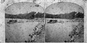
| Description: | Women in hats in foreground, with railroad tracks below and sign that says, "Look out for the cars," and "While the bell rings the whistle blows." Very lik... |
| Date: | 1874 |
|---|---|
| Description: | View west from the Cliff House at Devil's Lake. |

| Date: | 1877 |
|---|---|
| Description: | This 1877 map of Sauk County, Wisconsin, shows the township and range grid, sections, towns, cities and villages, land ownership and acreages, wagon roads,... |

| Date: | 1859 |
|---|---|
| Description: | Shows townships and sections, landownership, roads, railroads, rural residences, schools, churches, and topography. Relief shown by hachures. "From governm... |

| Date: | 1861 |
|---|---|
| Description: | This map shows townships and sections, landownership, roads, railroads, rural residences, schools, churches, and topography. Also included are inset maps o... |

| Date: | 1892 |
|---|---|
| Description: | A Sanborn fire insurance map of Sauk City which was drawn up in 1892. |
If you didn't find the material you searched for, our Library Reference Staff can help.
Call our reference desk at 608-264-6535 or email us at: