Filter: Categories of Wisconsin Historical Images
Filter: County of Sauk
Filter: Subject of land
Filter: Subject of rivers
Filter: Categories of Wisconsin Historical Images
Filter: County of Sauk
Filter: Subject of land
Filter: Subject of rivers
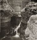
| Date: | |
|---|---|
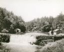
| Description: | Elevated view of dam at Pewit's Nest on Skillet Creek. |
| Date: | |
|---|---|
| Description: | Man and woman sitting on logs near the water line at Pewit's Nest. Wooden debris on ground and attached to rock face. A small waterfall is in background. |

| Date: | 1870 |
|---|---|
| Description: | Baraboo was first settled around 1838, and by 1870 it had become the county seat and the thriving village illustrated here. This birds eye drawing depicts ... |

| Date: | 1859 |
|---|---|
| Description: | Map featuring various views of buildings and scenes from Sauk County. |
| Date: | 1930 |
|---|---|
| Description: | View of the mill dam on Dell Creek that creates Mirror Lake in Mirror Lake State Park (although the photograph was taken before the site was designated as ... |
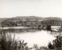
| Date: | 1925 |
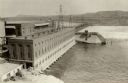
|---|---|
| Description: | Elevated view of dam and power station on a river. Two automobiles are parked in a lot in the lower left corner. Bluffs are in the distance. |
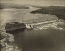
| Date: | 1924 |
|---|---|
| Description: | Aerial view of the Prairie du Sac hydroelectric plant and the surrounding landscape of the Wisconsin River. |
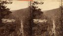
| Date: | |
|---|---|
| Description: | A view of a valley possibly in or around Devil's Lake. A man is visible in the foreground, hiking up the steep incline of the valley. |
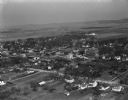
| Date: | 04 21 1949 |
|---|---|
| Description: | Aerial view of Spring Green. Houses and commercial buildings are in the foreground and a rural area is in the background. Hills are in the distance. |
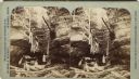
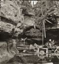
| Date: | |
|---|---|
| Description: | Two women and a man boat through a narrow passageway amidst large rock formations. Wooden debris from an unknown cause blocks their passage. This may be Pe... |
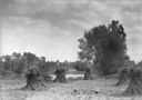
| Date: | 1925 |
|---|---|
| Description: | Corn shocks stand in a field with several pumpkins on the ground. There is a stream or river along the field, and in the background is a bridge over a dam... |
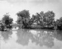
| Date: | 1930 |
|---|---|
| Description: | A view of high water on a river, possibly the Baraboo River, in a rural setting. |
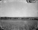
| Date: | 1920 |
|---|---|
| Description: | A view of a rolling rural landscape, most likely in Sauk County. In the far distance are houses and farm buildings, a church and a larger building, center ... |
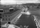
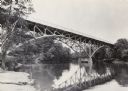
| Date: | 1936 |
|---|---|
| Description: | Elevated view of the power dam on the Wisconsin River at Prairie du Sac. |

| Date: | |
|---|---|
| Description: | Entrance to Cold Water Canyon near Wisconsin Dells. In the foreground is a wooden walkway across the water. |

| Date: | |
|---|---|
| Description: | Map of Baraboo and its surroundings, showing the ancient mound city, the water power, and thoroughfares, drawn by William H. Canfield. Canfield includes sk... |

| Date: | 1912 |
|---|---|
| Description: | This outline map of Sauk County, Wisconsin, shows the towns, cities and villages, railroads, and streams in the county. |
If you didn't find the material you searched for, our Library Reference Staff can help.
Call our reference desk at 608-264-6535 or email us at: