 Filter: Categories of Wisconsin Historical Images
Filter: County of Sauk
Filter: Subject of lakes
Filter: Subject of roads
Filter: Categories of Wisconsin Historical Images
Filter: County of Sauk
Filter: Subject of lakes
Filter: Subject of roads
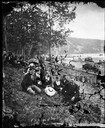
| Date: | 1877 |
|---|---|
| Description: | Well-dressed young couples sit in the foreground. In the background is a picket fence running along a busy road with horse and buggy traffic. Further on is... |

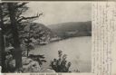
| Date: | |
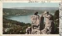
|---|---|
| Description: | Elevated view from rocks overlooking a valley toward Devil's Lake. Several houses are near a road that leads to the shoreline. |
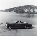
| Date: | 1956 |
|---|---|
| Description: | Lewis, LuRay, Nellie and Bernard Arms arrive at Devil's Lake in a maroon DeSoto convertible automobile. This was the day after Lewis and LuRay's wedding. |
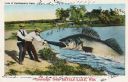
| Date: | 07 28 1933 |
|---|---|
| Description: | Colorized postcard in the Tall-Tale style. Two men standing on the shore are pulling a third man's leg out of a enormous fish's mouth. Two automobiles and ... |

| Date: | 1914 |
|---|---|
| Description: | Colorized postcard of the rock formation called the Devil's Doorway in Devil's Lake State Park. Trees can be seen below. The lake, bluffs, roads and buildi... |

| Date: | 06 28 1912 |
|---|---|
| Description: | Colorized postcard view of the rock formation called the Devil's Doorway in Devil's Lake State Park. Trees are growing among the rocks. The lake, bluffs, b... |

| Date: | 1939 |
|---|---|
| Description: | This map of Sauk County, Wisconsin, shows the township and range grid, towns, sections, cities and villages, roads, railroads, lakes and rivers, schools, a... |

| Date: | 1923 |
|---|---|
| Description: | This topographical map of Devil's Lake State Park, Sauk County, Wisconsin, is based on 1922-1923 surveys of the area by the University of Wisconsin Summer ... |

| Date: | 1926 |
|---|---|
| Description: | Map showing Devil's Lake State Park limits, railroads, roads, creeks, trails, and park sites. Accompanying text about the location, natural features, attra... |

| Date: | 1915 |
|---|---|
| Description: | This 1915 map covers the section of the Wisconsin River in southern Adams, southeastern Juneau, northeastern Sauk, and northwestern Columbia counties. A po... |

| Date: | 1859 |
|---|---|
| Description: | Shows townships and sections, landownership, roads, railroads, rural residences, schools, churches, and topography. Relief shown by hachures. "From governm... |
| Date: | 1906 |
|---|---|
| Description: | View from bluff of Devil's Lake. A road runs along the far shoreline. Caption reads: "Devil's Lake, Baraboo, Wis." |
| Date: | 1898 |
|---|---|
| Description: | Colorized postcard view of the Devil's Doorway rock formation overlooking Devil's Lake. Caption reads: "Devil's Doorway, Devil's Lake, Wis." |

| Date: | 1861 |
|---|---|
| Description: | This map shows townships and sections, landownership, roads, railroads, rural residences, schools, churches, and topography. Also included are inset maps o... |

| Date: | 1935 |
|---|---|
| Description: | The bluffs and lake appear hazy beyond an unpaved road and simple wooden bridge at Devil's Lake State Park. A man or boy at the shoreline can be seen throu... |
If you didn't find the material you searched for, our Library Reference Staff can help.
Call our reference desk at 608-264-6535 or email us at: