 Filter: Categories of Wisconsin Historical Images
Filter: County of Sauk
Filter: Subject of botany
Filter: Subject of railroads
Filter: Categories of Wisconsin Historical Images
Filter: County of Sauk
Filter: Subject of botany
Filter: Subject of railroads

| Date: | 1883 |
|---|---|
| Description: | Bird's-eye map of Prairie du Sac, Wisconsin with an inset of Clifton. |
| Date: | 1877 |
|---|---|
| Description: | Women in hats in foreground, with railroad tracks below and sign that says, "Look out for the cars," and "While the bell rings the whistle blows." Very lik... |
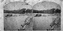
| Date: | 1874 |
|---|---|
| Description: | View west from the Cliff House at Devil's Lake. |
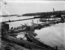
| Date: | 08 15 1911 |
|---|---|
| Description: | Dam site on the Wisconsin river, looking southwest along the unfinished narrow gauge railroad trestle. The coffer dam and two pile drivers are also visible... |
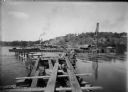
| Date: | 10 07 1911 |
|---|---|
| Description: | Elevated view of the rising waters of the Wisconsin River at the construction site. This view shows the coffer dam, pile drivers, and narrow gauge railroad... |
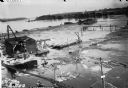
| Date: | 10 11 1911 |
|---|---|
| Description: | Elevated view of high water on the Wisconsin River which has inundated the coffer dam at the construction site. The narrow gauge railroad (curved line in f... |
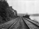
| Date: | |
|---|---|
| Description: | View of Chicago, Northwestern Railroad set of two railroad tracks at Devil's Lake, chartered in 1859. To the right, power lines run the length of the Devil... |

| Date: | 1948 |
|---|---|
| Description: | This outline map of Sauk County, Wisconsin, shows the towns, cities and villages, railroads, and streams in the county. |

| Date: | 1920 |
|---|---|
| Description: | This map of Devil's Lake State Park in Sauk County, Wisconsin, shows the park limits, railroads, roads, creeks, trails, and points of interest in the area.... |

| Date: | 1923 |
|---|---|
| Description: | This topographical map of Devil's Lake State Park, Sauk County, Wisconsin, is based on 1922-1923 surveys of the area by the University of Wisconsin Summer ... |

| Date: | 1926 |
|---|---|
| Description: | Map showing Devil's Lake State Park limits, railroads, roads, creeks, trails, and park sites. Accompanying text about the location, natural features, attra... |
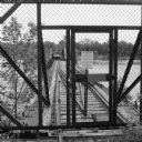
| Date: | 06 2014 |
|---|---|
| Description: | View through chain-link fence towards the railroad trestle that spans the Wisconsin River, worn with age, and split apart in the middle. There is a padlock... |

| Date: | 1911 |
|---|---|
| Description: | Stack of logs with the caption "Piles to be used for extending R.R. to dam site." |
If you didn't find the material you searched for, our Library Reference Staff can help.
Call our reference desk at 608-264-6535 or email us at: