 Filter: Categories of Wisconsin Historical Images
Filter: County of Sauk
Filter: Subject of architecture
Filter: Subject of railroads
Filter: Categories of Wisconsin Historical Images
Filter: County of Sauk
Filter: Subject of architecture
Filter: Subject of railroads

| Date: | 1883 |
|---|---|
| Description: | Bird's-eye map of Prairie du Sac, Wisconsin with an inset of Clifton. |
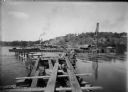
| Date: | 08 15 1911 |
|---|---|
| Description: | Dam site on the Wisconsin river, looking southwest along the unfinished narrow gauge railroad trestle. The coffer dam and two pile drivers are also visible... |
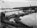
| Date: | 10 07 1911 |
|---|---|
| Description: | Elevated view of the rising waters of the Wisconsin River at the construction site. This view shows the coffer dam, pile drivers, and narrow gauge railroad... |
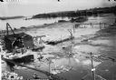
| Date: | 10 11 1911 |
|---|---|
| Description: | Elevated view of high water on the Wisconsin River which has inundated the coffer dam at the construction site. The narrow gauge railroad (curved line in f... |

| Date: | 1877 |
|---|---|
| Description: | This 1877 map of Sauk County, Wisconsin, shows the township and range grid, sections, towns, cities and villages, land ownership and acreages, wagon roads,... |

| Date: | 1939 |
|---|---|
| Description: | This map of Sauk County, Wisconsin, shows the township and range grid, towns, sections, cities and villages, roads, railroads, lakes and rivers, schools, a... |

| Date: | 1923 |
|---|---|
| Description: | This topographical map of Devil's Lake State Park, Sauk County, Wisconsin, is based on 1922-1923 surveys of the area by the University of Wisconsin Summer ... |

| Date: | 1915 |
|---|---|
| Description: | This 1915 map covers the section of the Wisconsin River in southern Adams, southeastern Juneau, northeastern Sauk, and northwestern Columbia counties. A po... |

| Date: | 1859 |
|---|---|
| Description: | Shows townships and sections, landownership, roads, railroads, rural residences, schools, churches, and topography. Relief shown by hachures. "From governm... |

| Date: | 1903 |
|---|---|
| Description: | This blue line print shows quartzite areas, mines, railroads, and roads. The map covers townships 11-13 north, ranges 4-8 east, in parts of Sauk and Columb... |

| Date: | 1900 |
|---|---|
| Description: | A Sanborn fire insurance map of Sauk City created in 1900. |

| Date: | 1915 |
|---|---|
| Description: | A Sanborn fire insurance map of Sauk City created in 1915. |
If you didn't find the material you searched for, our Library Reference Staff can help.
Call our reference desk at 608-264-6535 or email us at: