 Filter: Categories of Wisconsin Historical Images
Filter: County of Sauk
Filter: Type of Map or Atlas
Filter: Categories of Wisconsin Historical Images
Filter: County of Sauk
Filter: Type of Map or Atlas

| Date: | 1866 |
|---|---|
| Description: | This manuscript map by Increase Lapham shows the Dells of the Wisconsin River, from Stand Rock and Witches Gulch at the north to a point approximately one ... |

| Date: | 1915 |
|---|---|
| Description: | This 1915 map covers the section of the Wisconsin River in southern Adams, southeastern Juneau, northeastern Sauk, and northwestern Columbia counties. A po... |

| Date: | 1859 |
|---|---|
| Description: | Shows townships and sections, landownership, roads, railroads, rural residences, schools, churches, and topography. Relief shown by hachures. "From governm... |

| Date: | 09 1893 |
|---|---|
| Description: | Shows townships and sections, landownership and acreages, buildings, and school districts. Includes vignettes of local buildings, business directory, list ... |

| Date: | 07 1870 |
|---|---|
| Description: | This map of Ironton is pen-and-ink on paper and shows lots and block numbers, mill, foundry buildings, limestone quarry, iron mine, and roads. Relief is sh... |
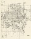
| Date: | 1972 |
|---|---|
| Description: | This map shows plat of the city, city limits, local streets, and part of the Baraboo River. The map includes 3 inset maps. |

| Date: | 1975 |
|---|---|
| Description: | This map shows plat of the city, city limits, local streets, and part of Baraboo River. The map includes 2 inset maps and a legend showing residential, bus... |

| Date: | 03 1964 |
|---|---|
| Description: | This map shows lot and block numbers, some landownership, disposal plant and pumping station, streets, parks, and vacated land. Lake Delton and streets are... |
| Date: | 1932 |
|---|---|
| Description: | This blue line print plat map shows local streets, numbered blocks and lots, village limits, and land ownership by name. Also included are manuscript annot... |

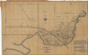
| Date: | 1861 |
|---|---|
| Description: | This map shows townships and sections, landownership, roads, railroads, rural residences, schools, churches, and topography. Also included are inset maps o... |

| Date: | 12 1903 |
|---|---|
| Description: | This manuscript blueprint map shows streets and lots and includes certifications in the left margin. Horizontal streets top to bottom are: Iroquois, Main, ... |

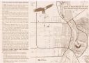
| Date: | 1940 |
|---|---|
| Description: | This pictorial map shows points of interest, recreation activities, and highways in the vicinity of the restaurant and covers the Wisconsin River Valley be... |
| Date: | 1999 |
|---|---|
| Description: | This map shows the best places to view bald eagles and areas to avoid when watching for eagles. The back of the map includes text and illustrations. |

| Date: | 1949 |
|---|---|
| Description: | This map shows points of interest, historic sites, buildings, trails, roads, and general animal and plant locations. |

| Date: | 1903 |
|---|---|
| Description: | This blue line print shows quartzite areas, mines, railroads, and roads. The map covers townships 11-13 north, ranges 4-8 east, in parts of Sauk and Columb... |

| Date: | 1904 |
|---|---|
| Description: | This blue line print map includes 4 cross sections with relief shown by contours and spot heights. The topography was taken from the United States Geologic... |

| Date: | 1892 |
|---|---|
| Description: | A Sanborn fire insurance map of Sauk City which was drawn up in 1892. |

| Date: | 1900 |
|---|---|
| Description: | A Sanborn fire insurance map of Sauk City created in 1900. |

| Date: | 1915 |
|---|---|
| Description: | A Sanborn fire insurance map of Sauk City created in 1915. |

| Date: | 1915 |
|---|---|
| Description: | A Sanborn fire insurance map of Sauk City created in 1915. |
If you didn't find the material you searched for, our Library Reference Staff can help.
Call our reference desk at 608-264-6535 or email us at: