Filter: Categories of Wisconsin Historical Images
Filter: County of Rock
Filter: Year of 1800-1899
Filter: Year of 1850-1859
Filter: Categories of Wisconsin Historical Images
Filter: County of Rock
Filter: Year of 1800-1899
Filter: Year of 1850-1859
| Date: | 1858 |
|---|---|
| Description: | Drawing of the exterior of the Shopiere Flouring Mill. Several men, some in a horse-drawn wagon are in front of the building. |

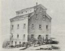
| Date: | 1858 |
|---|---|
| Description: | This 1858 map of Rock County, Wisconsin, shows the township and range grid, towns, sections, cities and villages, railroads, roads, property owners and res... |

| Date: | 1853 |
|---|---|
| Description: | Map covers area between the cities of Janesville and Kenosha in Rock, Walworth, and Kenosha counties for railroad routes. Lakes and counties are labelled. ... |

| Date: | 1850 |
|---|---|
| Description: | This map shows a plat of the town, land owners by name, local streets, railroads, churches, and part of the Rock River. The map is also indexed by church d... |
If you didn't find the material you searched for, our Library Reference Staff can help.
Call our reference desk at 608-264-6535 or email us at: