 Filter: Categories of Wisconsin Historical Images
Filter: County of Rock
Filter: Subject of transportation
Filter: Categories of Wisconsin Historical Images
Filter: County of Rock
Filter: Subject of transportation

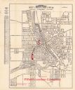
| Date: | 1873 |
|---|---|
| Description: | This map shows land ownership by name, local streets, railroads, parks, college grounds, schools, cemeteries, and part of Rock River. The upper left margin... |
| Date: | 02 11 1961 |
|---|---|
| Description: | Ninety-two foreign students attending the U.W., Beloit, and Milton Colleges representing 35 countries took buses to Janesville where they were guests of th... |

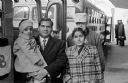
| Date: | 05 13 1945 |
|---|---|
| Description: | Frances Reneau with her son Thomas on her lap seated on a lawn on a residential street. Mrs. Reneau wears a corsage on her lapel and the toddler, Thomas, h... |
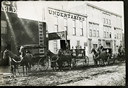
| Date: | |
|---|---|
| Description: | View from across unpaved street of four men with horse-drawn hearses lined up in front of an undertaking building. The other storefronts are a stable on th... |
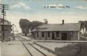
| Date: | 1910 |
|---|---|
| Description: | Colorized postcard view of the railroad station yard master's tower. Caption reads: "R. R. Station, Clinton, Wis." |
| Date: | 1924 |
|---|---|
| Description: | This map of Janesville was distrusted by the Fifield Lumber Company and features labeled streets, the Rock River, and Fifield Lumber Company buildings in r... |
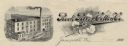
| Date: | |
|---|---|
| Description: | Memohead of the Rock River Cotton Company, with an elevated three-quarter view of the company building on the left, and a branch of the cotton plant with b... |
| Date: | 1960 |
|---|---|
| Description: | This blue line print map shows lot and block numbers and dimensions, some landownership, roads, and railroads. The map includes manuscript annotations of a... |

| Date: | 1836 |
|---|---|
| Description: | This map is ink on tracing paper and shows block numbers, streets, lot numbers of block no. 6, and a public square in Newburgh, a paper city (a city planne... |
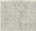
| Date: | 1955 |
|---|---|
| Description: | This cadastral map shows highways, land owners, railroads, and rivers. |
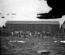
| Date: | 1900 |
|---|---|
| Description: | Group of farm workers are standing and posing in a field while threading tobacco leaves on lathes for drying. Two children and a dog are standing in the ce... |

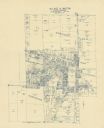
| Date: | 10 1969 |
|---|---|
| Description: | A street map of Janesville showing the block numbers on each street. Other landmarks are labeled such as chain stores, parks, schools, manufacturing compa... |
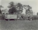
| Date: | 09 09 1948 |
|---|---|
| Description: | View across harvested field towards a man using a wagon and an ensilage harvester drawn by a Farmall M tractor on 132 acre farm of A.W. Reisseeum. In the b... |

| Date: | 1911 |
|---|---|
| Description: | This map shows streets, railroads, the city house numbering system, and the Rock River. The left margin includes a street index. |
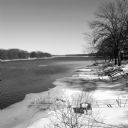
| Date: | 03 2014 |
|---|---|
| Description: | View looking down slope towards ice floes drifting down the Rock River. The steel frame of a dock protrudes from the shoreline on the left, which has a cov... |

| Date: | 05 16 1952 |
|---|---|
| Description: | Great grandchildren of Ole Knutson Nattestad, the first Norwegian settler in Wisconsin, Sonja Kay and John Carlton, standing with their parents, Mr. and Mr... |

| Date: | 05 16 1952 |
|---|---|
| Description: | Judge Chester R. Christensen, Rock County Judge, speaking at the dedication ceremony of the Jefferson Prairie Settlement historical marker. Seated behind h... |
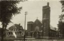
| Date: | 1907 |
|---|---|
| Description: | Black and white photographic postcard view from across the street towards the Catholic Church and parsonage. The church has a rose window above the entranc... |
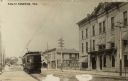
| Date: | 1911 |
|---|---|
| Description: | View down Main Street towards a streetcar coming up the street. On the opposite side of the street are commercial buildings. The Monarch Building is in the... |
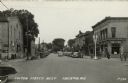
| Date: | 1948 |
|---|---|
| Description: | View down center of Fulton Street which is lined with street lamps, parked cars, and commercial buildings. Pedestrians are strolling along the street and s... |
If you didn't find the material you searched for, our Library Reference Staff can help.
Call our reference desk at 608-264-6535 or email us at: