 Filter: Categories of Wisconsin Historical Images
Filter: County of Rock
Filter: Subject of transportation
Filter: Subject of cities and towns
Filter: Categories of Wisconsin Historical Images
Filter: County of Rock
Filter: Subject of transportation
Filter: Subject of cities and towns
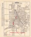
| Date: | 1924 |
|---|---|
| Description: | This map of Janesville was distrusted by the Fifield Lumber Company and features labeled streets, the Rock River, and Fifield Lumber Company buildings in r... |
| Date: | |
|---|---|
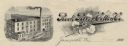
| Description: | Memohead of the Rock River Cotton Company, with an elevated three-quarter view of the company building on the left, and a branch of the cotton plant with b... |
| Date: | 1960 |
|---|---|
| Description: | This blue line print map shows lot and block numbers and dimensions, some landownership, roads, and railroads. The map includes manuscript annotations of a... |

| Date: | 1836 |
|---|---|
| Description: | This map is ink on tracing paper and shows block numbers, streets, lot numbers of block no. 6, and a public square in Newburgh, a paper city (a city planne... |
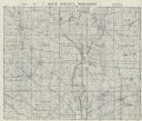
| Date: | 1955 |
|---|---|
| Description: | This cadastral map shows highways, land owners, railroads, and rivers. |

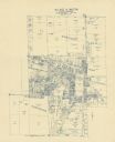
| Date: | 10 1969 |
|---|---|
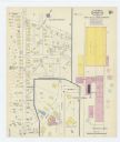
| Description: | A street map of Janesville showing the block numbers on each street. Other landmarks are labeled such as chain stores, parks, schools, manufacturing compa... |

| Date: | 1911 |
|---|---|
| Description: | This map shows streets, railroads, the city house numbering system, and the Rock River. The left margin includes a street index. |
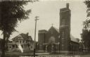
| Date: | 1907 |
|---|---|
| Description: | Black and white photographic postcard view from across the street towards the Catholic Church and parsonage. The church has a rose window above the entranc... |
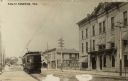
| Date: | 1911 |
|---|---|
| Description: | View down Main Street towards a streetcar coming up the street. On the opposite side of the street are commercial buildings. The Monarch Building is in the... |
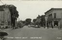
| Date: | 1948 |
|---|---|
| Description: | View down center of Fulton Street which is lined with street lamps, parked cars, and commercial buildings. Pedestrians are strolling along the street and s... |

| Date: | 1906 |
|---|---|
| Description: | Slightly elevated view of a parade on Front Street. Crowds of people are watching from the sidewalks. Caption reads: "Front St., Edgerton, Wis." |
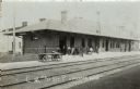
| Date: | 1907 |
|---|---|
| Description: | View across railroad tracks towards the station. People and push carts are along the platform. One man has a bicycle. Caption reads: "C.M. and St. P. Edger... |

| Date: | 1906 |
|---|---|
| Description: | View of the city hall and church. Both buildings have bell towers. Caption reads: "City Hall and Methodist Church, Evansville, Wis." |

| Date: | |
|---|---|
| Description: | Hand-colored view from intersection towards the First Baptist Church, with a bell-tower above the corner entrance. Caption reads: "First Baptist Church, Ev... |
| Date: | 1915 |
|---|---|
| Description: | A Sanborn map of a portion of Janesville, including the Rock River Sugar Company. |
| Date: | |
|---|---|
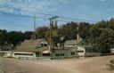
| Description: | Color postcard view from intersection towards a roadside tavern. Text on reverse reads: "TIBBIES Where Chicken is King at Indian Ford, Wis. Three miles... |

| Date: | |
|---|---|
| Description: | Hand-colored view of central Janesville from the Rock River. A bridge, excursion boat and warehouses are in the foreground. Caption reads: "Fourth Ave., Br... |
| Date: | 1908 |
|---|---|
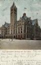
| Description: | View across intersection towards the Government Building with arched entrances and turrets. Caption reads: "U.S. Government Building and Post Office." |

| Date: | |
|---|---|
| Description: | View across street towards the Parker Pen Factory, with a large, electric sign on the roof. Caption reads: "Parker Pen Company, Janesville, Wis." |
If you didn't find the material you searched for, our Library Reference Staff can help.
Call our reference desk at 608-264-6535 or email us at:
