Filter: Categories of Wisconsin Historical Images
Filter: County of Rock
Filter: Subject of lakes
Filter: Categories of Wisconsin Historical Images
Filter: County of Rock
Filter: Subject of lakes
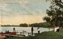
| Date: | 1908 |
|---|---|
| Description: | View towards people standing on the shoreline near a boat landing at Yosts Park. A man and a dog are standing on the pier, and a group of people are in a b... |

| Date: | 1920 |
|---|---|
| Description: | Two cottages at Burgy Mounds on Lake Koshkonong. |

| Date: | 1920 |
|---|---|
| Description: | View from shore of a group of men posing on a dock at Burgy Mounds on Lake Koshkonong. Boats are tied to the dock. There are a number of people in boats fa... |

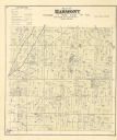
| Date: | 1858 |
|---|---|
| Description: | This 1858 map of Rock County, Wisconsin, shows the township and range grid, towns, sections, cities and villages, railroads, roads, property owners and res... |

| Date: | 1853 |
|---|---|
| Description: | Map covers area between the cities of Janesville and Kenosha in Rock, Walworth, and Kenosha counties for railroad routes. Lakes and counties are labelled. ... |
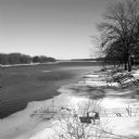
| Date: | 03 2014 |
|---|---|
| Description: | View looking down slope towards ice floes drifting down the Rock River. The steel frame of a dock protrudes from the shoreline on the left, which has a cov... |
If you didn't find the material you searched for, our Library Reference Staff can help.
Call our reference desk at 608-264-6535 or email us at: