Filter: Categories of Wisconsin Historical Images
Filter: County of Richland
Filter: Subject of land use
Filter: Categories of Wisconsin Historical Images
Filter: County of Richland
Filter: Subject of land use
| Date: | 09 24 1960 |
|---|---|
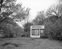
| Description: | An isolated shack that was formerly an antique dealer's store. |
| Date: | 03 1876 |
|---|---|
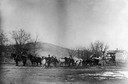
| Description: | The first locomotive for the Pine River & Stevens Point ralroad, which was purchased in 1875, being hauled overland from Lone Rock to Richland Center while... |

| Date: | 03 1876 |
|---|---|
| Description: | Side view of the locomotive purchased by the Pine River and Stevens Point Railroad, being hauled over land from Lone Rock to Richland Center. In the backgr... |
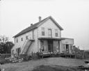
| Date: | 1870 |
|---|---|
| Description: | View across road towards several buildings, including A.H. Krouskop's store. |
| Date: | 1916 |
|---|---|
| Description: | Panoramic view of the section of State Highway 115 in Richland County known as Muscoda-Richland Center Road. Grading and improvement of this hilly section... |
| Date: | 1920 |
|---|---|
| Description: | The Coumbe homestead, home of John Coumbe, the first white settler in Richland County, who came to the site in 1838. The original buildings were log struct... |
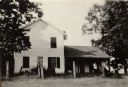
| Date: | 1920 |
|---|---|
| Description: | The Coumbe homestead, home of John Coumbe, the first white settler in Richland County, who came to the site in 1838. This home was built in 1861-62; the or... |
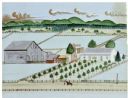
| Date: | 1910 |
|---|---|
| Description: | Painting of farm depicting farmhouse, barn, and windmill. Located east of Gotham on Old Lone Rock Road. |
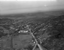
| Date: | 03 28 1949 |
|---|---|
| Description: | Aerial photographs of Richland Center, Wisconsin. |
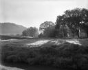
| Date: | 08 12 1961 |
|---|---|
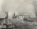
| Description: | Early sun seeps through a tree line and buildings into a creek valley. There is a creek in the foreground. |
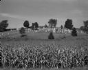
| Date: | 09 1967 |
|---|---|
| Description: | View over cornfield of a cemetery on the side of a hill surrounded by a fence. On the hill behind the cemetery are more cornfields. |
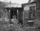
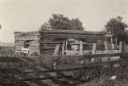
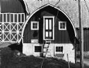
| Date: | 09 24 1960 |
|---|---|
| Description: | View of part of an abandoned, weathered farmhouse which is surrounded by overgrown weeds. |

| Date: | 05 19 1966 |
|---|---|
| Description: | Pasture with logs near fence and road. On the other side of the road is a barn and farm buildings. In the background is a tree-lined ridge. |
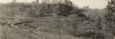
| Date: | 09 1979 |
|---|---|
| Description: | Milk house, US Highway 14, west of Richland Center. |

| Date: | 07 03 1960 |
|---|---|
| Description: | View looking uphill toward a new housing development. The street in the foreground is still under construction. |
| Date: | |
|---|---|
| Description: | Four men, a dog and a boy sitting on the porch of the general store. Signs in the windows read, "Ferry & Co. Seeds" and "Rape seed for sale." A barn and wi... |

| Date: | |
|---|---|
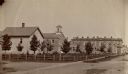
| Description: | Exterior view of church. The building features a belfry, steeple, and double doors. There is a cemetery in a fence adjacent to the church. |
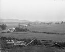
| Date: | |
|---|---|
| Description: | Rich Valley looking down at Mill Creek Valley. There are several farmhouses among the fields. |
If you didn't find the material you searched for, our Library Reference Staff can help.
Call our reference desk at 608-264-6535 or email us at: