Filter: Categories of Wisconsin Historical Images
Filter: County of Racine
Filter: Subject of transportation
Filter: Categories of Wisconsin Historical Images
Filter: County of Racine
Filter: Subject of transportation

| Date: | 12 20 1957 |
|---|---|
| Description: | View across harbor from small boat ramp towards far shoreline. On the far shoreline is industrial machinery, piles of coal, and other buildings. |

| Date: | 12 10 1957 |
|---|---|
| Description: | View of harbor with pilings in the right foreground. There is a lighthouse on breakwaters in the distance. |

| Date: | 11 03 1958 |
|---|---|
| Description: | This map shows lot and block numbers and dimensions, some landownership, streets, and limits of the proposed village. The map includes certificate by the s... |

| Date: | 1867 |
|---|---|
| Description: | This map shows components of the bottom of Lake Michigan and the Root River, as well as the harbor, buildings, streets, railroads, and rural landowners in ... |

| Date: | 10 1853 |
|---|---|
| Description: | This map shows warehouses and proposed extensions of piers. "Note: The soundings are in feet and tenths." The upper left margin reads: "Senate Ex. Doc. No.... |

| Date: | 10 1853 |
|---|---|
| Description: | This map shows warehouses and proposed extensions of piers. Also included are notes on soundings and the proposed extensions. The upper right margin reads:... |

| Date: | 1926 |
|---|---|
| Description: | This blueprint map shows streets, industrial, and public buildings in the vicinity of harbor. |

| Date: | 06 12 1929 |
|---|---|
| Description: | This manuscript blueprint shows buildings with the names of their owners, tabernacle, location "where Strang found plates" and "house where Strang died," a... |
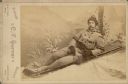
| Date: | 1890 |
|---|---|
| Description: | Portrait of a man wearing a stocking cap, mittens and a double-breasted coat reclines on a toboggan which is supported on a studio prop at an angle in fron... |
| Date: | 1890 |
|---|---|
| Description: | A large, long haired dog looks attentively toward the camera. He is standing near a water hydrant in the side yard of a house. The corner of the house with... |
| Date: | 1900 |
|---|---|
| Description: | This map shows plots and streets as well at the Root River. The bottom margin and back of the map include extensive certifications. |

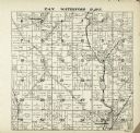
| Date: | 1921 |
|---|---|
| Description: | This map shows selected streets, public buildings, churches, schools, businesses, warehouses, the harbor, the Root River, and Lake Michigan. The map includ... |
| Date: | 1912 |
|---|---|
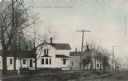
| Description: | Hand-colored view of the Methodist parsonage and its surrounding neighborhood. Caption reads: "M.E. Parsonage, Franksville, Wis." |
| Date: | 1912 |
|---|---|
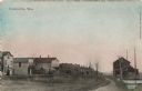
| Description: | Hand-colored scene of central Franksville. View down road towards dwellings and businesses. Caption reads: "Franksville, Wis." |
| Date: | 1908 |
|---|---|
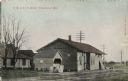
| Description: | Hand-colored view of the Franksville Depot, a small wooden building next to the tracks. Caption reads: "C. M. & St. P. Depot, Franksville, Wis." |
| Date: | 09 1907 |
|---|---|
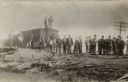
| Description: | A group of men and boys are standing amid the wreckage of a train. |
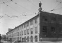
| Date: | 07 1936 |
|---|---|
| Description: | "Old Abe," the bald eagle trademark of the J.I. Case Company, is shown roosting on a world globe with "CASE" written on it, on the corner of a parapet on t... |

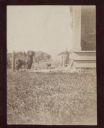
| Date: | 1888 |
|---|---|
| Description: | Exterior of church, which is partially obscured by trees. |
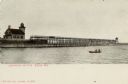
| Date: | 1916 |
|---|---|
| Description: | Tinted postcard of the lighthouse and a light tower at the end of a pier. A small boat with two passengers is on the water. This would be the Racine North ... |
If you didn't find the material you searched for, our Library Reference Staff can help.
Call our reference desk at 608-264-6535 or email us at: