 Filter: Categories of Wisconsin Historical Images
Filter: County of Racine
Filter: Subject of roads
Filter: Subject of industries
Filter: Categories of Wisconsin Historical Images
Filter: County of Racine
Filter: Subject of roads
Filter: Subject of industries
| Date: | |
|---|---|
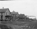
| Description: | View down a dirt road with houses lining the street. A factory is visible in the distance. |

| Date: | 1972 |
|---|---|
| Description: | This map on 5 sheets features a title page sheet with business directory and shows section numbers, roads, railroads, saw mills, churches, blacksmith shops... |

| Date: | 1926 |
|---|---|
| Description: | This blueprint map shows streets, industrial, and public buildings in the vicinity of harbor. |

| Date: | 06 12 1929 |
|---|---|
| Description: | This manuscript blueprint shows buildings with the names of their owners, tabernacle, location "where Strang found plates" and "house where Strang died," a... |
If you didn't find the material you searched for, our Library Reference Staff can help.
Call our reference desk at 608-264-6535 or email us at: