Filter: Categories of Wisconsin Historical Images
Filter: County of Racine
Filter: Subject of land
Filter: Subject of lakes
Filter: Categories of Wisconsin Historical Images
Filter: County of Racine
Filter: Subject of land
Filter: Subject of lakes

| Date: | 1972 |
|---|---|
| Description: | This map on 5 sheets features a title page sheet with business directory and shows section numbers, roads, railroads, saw mills, churches, blacksmith shops... |

| Date: | 1858 |
|---|---|
| Description: | This 1858 map of Racine County, Wisconsin, shows land ownership and acreages, the township and range grid, towns, cities and villages, roads, railroads, sc... |

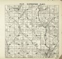
| Date: | 1896 |
|---|---|
| Description: | This 1896 map of Racine and Kenosha counties, Wisconsin, shows the township and range grid, towns, sections, cities, villages and post offices, roads, rail... |

| Date: | 1942 |
|---|---|
| Description: | This map of Burlington shows plat of the town, city limits, section lines, 1/4 section lines of the plat sections, roads, railroads, rivers, and lakes. The... |

| Date: | 1910 |
|---|---|
| Description: | Watercolor design for a conservation poster made by a Wisconsin high school student as part of a competition. The poster has an image of pine trees in a me... |

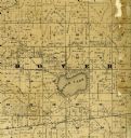
| Date: | 1887 |
|---|---|
| Description: | A plat map of Waterford. Township 4, North Range 19, East of 4th Principal Meridian. References at bottom include school houses, houses, churches and cemet... |
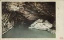
| Date: | 1907 |
|---|---|
| Description: | Text on front reads: "Ice Cave. Winter on Lake Michigan. Racine, Wis." The logo for the Detroit Publishing Company is in the lower right corner. Water leve... |
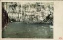
| Date: | 1907 |
|---|---|
| Description: | Text on front reads: "Crystal Grotto. Winter on Lake Michigan. Racine, Wis." Water level view of an ice cave on the rocky shore. So many icicles are hangin... |

| Date: | 1960 |
|---|---|
| Description: | This standard U.S.G.S. topographic map was annotated by civil engineer and railroad historian James P. Kaysen to show the location of existing and defunct ... |
If you didn't find the material you searched for, our Library Reference Staff can help.
Call our reference desk at 608-264-6535 or email us at: