Filter: Categories of Wisconsin Historical Images
Filter: County of Racine
Filter: Subject of lakes
Filter: Categories of Wisconsin Historical Images
Filter: County of Racine
Filter: Subject of lakes
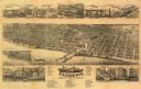
| Date: | 1883 |
|---|---|
| Description: | Bird's-eye map of Racine looking south west, with insets of points of interest. |

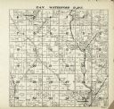
| Date: | 1907 |
|---|---|
| Description: | Text on front reads: "Racine, Wis. in 1850." Artist's rendering of the view of the harbor with sailing ships, sailboats, rowboats and canoes. The Main Stre... |
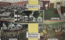
| Date: | |
|---|---|
| Description: | Color postcard of five views of Liggett's Resort on Brown's Lake. Front view, "Marine Dining Room," "Marine Bar," "Guest Room" and "Marine Lounge." |

| Date: | |
|---|---|
| Description: | Color postcard of an aerial view of Cerami's Island View Hotel Motel Resort on the shore of Brown's Lake. |
| Date: | 1952 |
|---|---|
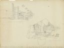
| Description: | Interior perspectives of the Robert Johns residence designed and drawn by architect John Randal McDonald. McDonald gave the project two names, "Spindrift"... |

| Date: | 1972 |
|---|---|
| Description: | This map on 5 sheets features a title page sheet with business directory and shows section numbers, roads, railroads, saw mills, churches, blacksmith shops... |

| Date: | 1858 |
|---|---|
| Description: | This 1858 map of Racine County, Wisconsin, shows land ownership and acreages, the township and range grid, towns, cities and villages, roads, railroads, sc... |

| Date: | 1896 |
|---|---|
| Description: | This 1896 map of Racine and Kenosha counties, Wisconsin, shows the township and range grid, towns, sections, cities, villages and post offices, roads, rail... |

| Date: | 1987 |
|---|---|
| Description: | This 1987 map of Racine and Kenosha counties, Wisconsin, shows towns, sections, cities and villages, zip code boundaries, highways and roads, bicycle route... |
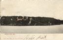
| Date: | |
|---|---|
| Description: | Colorized view of Brown's Lake. Buildings on the far shoreline are obscured by trees. Caption reads: "Brown's Lake, Wis." |

| Date: | 1909 |
|---|---|
| Description: | View of a camp by Bohner's Lake. Caption reads: "East Shore Bohner's Lake, Burlington." |

| Date: | 1942 |
|---|---|
| Description: | This map of Burlington shows plat of the town, city limits, section lines, 1/4 section lines of the plat sections, roads, railroads, rivers, and lakes. The... |

| Date: | 1910 |
|---|---|
| Description: | Watercolor design for a conservation poster made by a Wisconsin high school student as part of a competition. The poster has an image of pine trees in a me... |
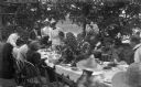
| Date: | 1897 |
|---|---|
| Description: | The Meinhardt family assembled for a picnic in their garden. A river or lake is in the far background. The table is set with china and flatware. Among the ... |

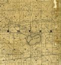
| Date: | 1887 |
|---|---|
| Description: | A plat map of Waterford. Township 4, North Range 19, East of 4th Principal Meridian. References at bottom include school houses, houses, churches and cemet... |

| Date: | 1915 |
|---|---|
| Description: | Text at top reads: "Racine, Wis. View from Top of Court-House." An elevated view of Racine including the harbor. Buildings, rooftops, signs, the gas works ... |
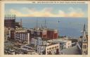
| Date: | 11 05 1943 |
|---|---|
| Description: | Text at top reads: "Lake Michigan from Top of Court House, Racine, Wisconsin." An elevated view of Racine including the harbor. Buildings, rooftops, signs,... |
If you didn't find the material you searched for, our Library Reference Staff can help.
Call our reference desk at 608-264-6535 or email us at: