 Filter: Categories of Wisconsin Historical Images
Filter: County of Racine
Filter: Subject of cemeteries
Filter: Year of 1900-1999
Filter: Categories of Wisconsin Historical Images
Filter: County of Racine
Filter: Subject of cemeteries
Filter: Year of 1900-1999
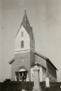
| Date: | 1921 |
|---|---|
| Description: | View from cemetery towards the front of the Muskego Church. People are standing near the entrance. |

| Date: | 1972 |
|---|---|
| Description: | This map on 5 sheets features a title page sheet with business directory and shows section numbers, roads, railroads, saw mills, churches, blacksmith shops... |

| Date: | 01 18 1907 |
|---|---|
| Description: | This map shows Lake Michigan, streets, schools, churches, businesses, cemeteries, parks, and railroads. Relief is shown by contours; depths are shown by so... |

| Date: | 06 12 1929 |
|---|---|
| Description: | This manuscript blueprint shows buildings with the names of their owners, tabernacle, location "where Strang found plates" and "house where Strang died," a... |
If you didn't find the material you searched for, our Library Reference Staff can help.
Call our reference desk at 608-264-6535 or email us at: