Filter: Categories of Wisconsin Historical Images
Filter: County of Racine
Filter: Type of Map or Atlas
Filter: Subject of roads
Filter: Categories of Wisconsin Historical Images
Filter: County of Racine
Filter: Type of Map or Atlas
Filter: Subject of roads

| Date: | 1972 |
|---|---|
| Description: | This map on 5 sheets features a title page sheet with business directory and shows section numbers, roads, railroads, saw mills, churches, blacksmith shops... |
| Date: | 1918 |
|---|---|
| Description: | This map shows the property owned by Edwin Bottomley and others at the confluence of Eagle Creek with the Fox River in the Town of Rochester, Racine County... |

| Date: | 1858 |
|---|---|
| Description: | This 1858 map of Racine County, Wisconsin, shows land ownership and acreages, the township and range grid, towns, cities and villages, roads, railroads, sc... |
| Date: | 1893 |
|---|---|
| Description: | This 1893 map of the eastern portion of Racine County, Wisconsin, shows land ownership and acreages, railroads, and roads in the towns of Caledonia and Mou... |

| Date: | 1896 |
|---|---|
| Description: | This 1896 map of Racine and Kenosha counties, Wisconsin, shows the township and range grid, towns, sections, cities, villages and post offices, roads, rail... |

| Date: | 1911 |
|---|---|
| Description: | This 1911 map shows the Post Office's rural routes in Racine County, Wisconsin, and portions of eastern Walworth and northern Kenosha counties. The locatio... |

| Date: | 1934 |
|---|---|
| Description: | This 1934 map of Racine County, Wisconsin, shows the township and range grid, cities and villages, vegetation type, land use, roads, railroads, utilities, ... |

| Date: | 1975 |
|---|---|
| Description: | This map shows settlers, Indian trails, roads, marshes, and forests as they appeared in 1800-1840. "A bicentennial map of Racine County for the benefit of ... |

| Date: | 1987 |
|---|---|
| Description: | This 1987 map of Racine and Kenosha counties, Wisconsin, shows towns, sections, cities and villages, zip code boundaries, highways and roads, bicycle route... |

| Date: | 1942 |
|---|---|
| Description: | This map of Burlington shows plat of the town, city limits, section lines, 1/4 section lines of the plat sections, roads, railroads, rivers, and lakes. The... |

| Date: | 1858 |
|---|---|
| Description: | This map shows lot and block numbers, landownership, buildings, railroads, roads, wards, points of interest, parks, and cemeteries. Also included are illus... |

| Date: | 1926 |
|---|---|
| Description: | This blueprint map shows streets, industrial, and public buildings in the vicinity of harbor. |

| Date: | 06 12 1929 |
|---|---|
| Description: | This manuscript blueprint shows buildings with the names of their owners, tabernacle, location "where Strang found plates" and "house where Strang died," a... |

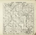
| Date: | 1887 |
|---|---|
| Description: | A plat map of Waterford. Township 4, North Range 19, East of 4th Principal Meridian. References at bottom include school houses, houses, churches and cemet... |
If you didn't find the material you searched for, our Library Reference Staff can help.
Call our reference desk at 608-264-6535 or email us at: