 Filter: Categories of Wisconsin Historical Images
Filter: County of Price
Filter: Subject of industries
Filter: Categories of Wisconsin Historical Images
Filter: County of Price
Filter: Subject of industries
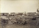
| Date: | 1895 |
|---|---|
| Description: | Railroad depot surrounded by stacked lumber for wood-burning locomotives. A few homes can be seen in the background. |
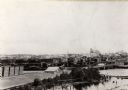
| Date: | 1890 |
|---|---|
| Description: | Elevated view of the town as it appeared before the fire of 1894. |
| Date: | 1900 |
|---|---|
| Description: | A view of the Park Hotel in winter. A man on the left is pulling a sled piled with firewood. |
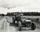
| Date: | 1948 |
|---|---|
| Description: | Man grading a dirt road with a Meili-Blumberg Model 10 power grader attached to an International M tractor. Original caption states: "To maintain its 67 m... |
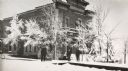
| Date: | 2008 |
|---|---|
| Description: | Rudy Kuchlenz built this clapboard-sided building at the crossroads of U.S. Highway 8 and County Highway J in the village of Kennan, in 1927. |
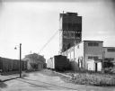
| Date: | 09 18 1961 |
|---|---|
| Description: | View from railroad tracks of the Flambeau Milling Company Plant. |
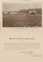
| Date: | 09 04 1895 |
|---|---|
| Description: | A promotional card depicting Oswald Scheller and his family on their farm in northern Wisconsin. The caption below the image reads: "Field of potatoes on... |

| Date: | 1888 |
|---|---|
| Description: | This late 19th century map of Price County, Wisconsin, shows landownership and waterfront acreages, the township and range system, towns, cities and villag... |

| Date: | 1914 |
|---|---|
| Description: | This 1914 map of Price County, Wisconsin, shows land for sale by the Good Land Company and Dewitt van Ostrand of Phillips. Also shown are the township and ... |

| Date: | 07 07 1915 |
|---|---|
| Description: | Ink on tracing cloth. Includes signed certifications from the surveyor, notary public, and Wisconsin Realty Company. From the E.P. Sherry papers relating t... |

| Date: | 1891 |
|---|---|
| Description: | This map shows vacant Southwick & Sellers lands, settlers' houses, Goodland Co. land, schools, churches, saw mills, roads, and railroads. A key in the uppe... |

| Date: | 07 1936 |
|---|---|
| Description: | Stacks of logs cover a large flat area in the foreground, and in the distance is a complex of buildings at a sawmill. There are many large stacks of lumber... |
If you didn't find the material you searched for, our Library Reference Staff can help.
Call our reference desk at 608-264-6535 or email us at: