 Filter: Categories of Wisconsin Historical Images
Filter: County of Price
Filter: Subject of botany
Filter: Categories of Wisconsin Historical Images
Filter: County of Price
Filter: Subject of botany
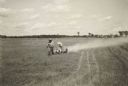
| Date: | 1938 |
|---|---|
| Description: | Dusting a cranberry marsh to combat blunt-nosed leaf-hoppers, Cranberry Lake Development Co. |
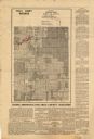
| Date: | 1935 |
|---|---|
| Description: | This map shows land zoning. The top middle includes a key of land zones, forestry, recreation, and unrestricted. The map includes extensive text on zoning ... |

| Date: | 1980 |
|---|---|
| Description: | The tall, straight trunk of a large white oak dwarfs others around it on land homesteaded by (Carl) Albert Meier in 1883. At the time of the photograph, th... |

| Date: | 03 1978 |
|---|---|
| Description: | View across snow-covered ground towards a man standing on a log. The trees around him are either broken or bent over towards the right, the result of a sto... |

| Date: | 07 1937 |
|---|---|
| Description: | View across water towards a shoreline where men and boys are gathered on the bank of the Flambeau River, with several canoes and rowboats pulled up to the ... |
| Date: | 1935 |
|---|---|
| Description: | View from rocky shoreline towards three young men in a canoe running the Little Falls rapids on the South Fork of the Flambeau River. |
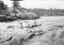
| Date: | 1950 |
|---|---|
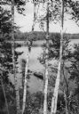
| Description: | Elevated view of a man fishing in a rowboat seen through a stand of Birch trees on Miles Lake. |
If you didn't find the material you searched for, our Library Reference Staff can help.
Call our reference desk at 608-264-6535 or email us at: