 Filter: Categories of Wisconsin Historical Images
Filter: County of Price
Filter: Creator Name of Unknown
Filter: Categories of Wisconsin Historical Images
Filter: County of Price
Filter: Creator Name of Unknown
| Date: | |
|---|---|
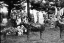
| Description: | View of several sculptures, including depictions of people, angels, and various animals in Fred Smith's Concrete Park. |
| Date: | |
|---|---|
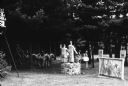
| Description: | View of several sculptures in Fred Smith's Concrete Park. |
| Date: | |
|---|---|
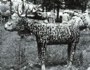
| Description: | Sculpture of a moose at Fred Smith's Concrete Park. |

| Date: | |
|---|---|
| Description: | Conservationist Sigurd Olson (front row, left) posing with his class, probably at Prentice, Wisconsin. |
| Date: | |
|---|---|
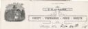
| Description: | Letterhead of the Price County Treasurer's office, with a three-quarter view of the county building, and people walking and children playing outside. Text ... |
| Date: | |
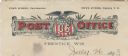
|---|---|
| Description: | Letterhead of the Post Office in Prentice, Wisconsin, with a banner that reads "Post Office" in red letters, and an eagle perched on a shield with stars an... |

| Date: | 1910 |
|---|---|
| Description: | This map is ink on paper. Shows Bruce’s proposed railway route and Moon’s railroad survey route along the Flambeau River, in parts of Lake and Eisenstein t... |
| Date: | 01 1934 |
|---|---|
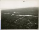
| Description: | Aerial view of a forest with a river running through it. |
| Date: | 1908 |
|---|---|
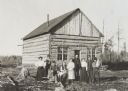
| Description: | Group posed in front of the first house built in Kennedy. |

| Date: | |
|---|---|
| Description: | Postcard advertising the Good Land Company with a photograph of a farm and information for "Homeseekers, Farmers and Investors." |

| Date: | 1903 |
|---|---|
| Description: | This blue line print map is oriented with the north to the left and shows buildings with dimensions, utilities, and proposed buildings. The Flambeau River ... |

| Date: | 1891 |
|---|---|
| Description: | This map shows vacant Southwick & Sellers lands, settlers' houses, Goodland Co. land, schools, churches, saw mills, roads, and railroads. A key in the uppe... |
| Date: | |
|---|---|
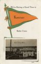
| Description: | An illustration of a pennant, and a photograph of the town. |
If you didn't find the material you searched for, our Library Reference Staff can help.
Call our reference desk at 608-264-6535 or email us at: