 Filter: Categories of Wisconsin Historical Images
Filter: County of Portage
Filter: Subject of architecture
Filter: Subject of roads
Filter: Categories of Wisconsin Historical Images
Filter: County of Portage
Filter: Subject of architecture
Filter: Subject of roads

| Date: | 1891 |
|---|---|
| Description: | Bird's-eye map of Stevens Point, looking east, with an inset of the Water Works. Wisconsin River in foreground with fifty-three business locations identifi... |
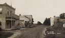
| Date: | 1905 |
|---|---|
| Description: | View down unpaved street with commercial buildings. Caption reads: "St. Scene, Bancroft, Wis." |

| Date: | |
|---|---|
| Description: | Exterior view from road of the Stevens Point Public Library. The library opened in 1904 and was funded by a $22,000 donation from Andrew Carnegie. Above th... |

| Date: | |
|---|---|
| Description: | View of Saint Stanislaus Kostka Catholic Church, completed in 1918. A staircase leads to the main entrance of the brick building with a belfry. |
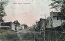
| Date: | |
|---|---|
| Description: | Color photographic postcard of the business district. Local business and homes are on on both sides of the main road. Horse-drawn wagons are parked on the ... |

| Date: | 08 24 1967 |
|---|---|
| Description: | Elevated view of 150 workers rallying as a part of Obreros Unidos (United Workers) protest against poor working conditions of migrant farm workers in the S... |

| Date: | |
|---|---|
| Description: | This map from the early 20th century shows the township and range grid, towns, sections, cities and villages, railroads, roads, schools, churches, cemeteri... |

| Date: | 1990 |
|---|---|
| Description: | This map, in addition to the Fort ground and buildings, shows owners of outbuildings, heights of buildings in stories, fences, roads, gardens, and cemetery... |
If you didn't find the material you searched for, our Library Reference Staff can help.
Call our reference desk at 608-264-6535 or email us at: