 Filter: Categories of Wisconsin Historical Images
Filter: County of Polk
Filter: Year of 1900-1999
Filter: Subject of transportation
Filter: Categories of Wisconsin Historical Images
Filter: County of Polk
Filter: Year of 1900-1999
Filter: Subject of transportation
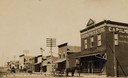
| Date: | 1926 |
|---|---|
| Description: | Main Street, with two competing curb-side gas stations across the street from each other. Cars are parked along both sides of the muddy street. Such curb-... |
| Date: | 1905 |
|---|---|
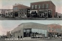
| Description: | Top view is from the intersection looking towards buildings on the right side of the street. The bottom view has a caption that reads: "West Side of Main S... |
| Date: | 1905 |
|---|---|
| Description: | View down Keller Avenue towards businesses along the left. A round or octagon shaped building on the far left has a sign that reads: "Restaurant". Further ... |
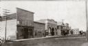
| Date: | 1905 |
|---|---|
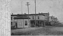
| Description: | Business section of downtown. View across unpaved road towards business along the left. A group of children and adults are posing standing in the road nea... |
| Date: | 1905 |
|---|---|
| Description: | West side of Main Street, with "The One Price Store" in the right foreground, and other commercial buildings further down the street. There are large utili... |
| Date: | 1905 |
|---|---|
| Description: | View down a dirt road with a general store on the left, with a sign that reads: "Merchandise". Men and a child are standing on the porch. On the right side... |

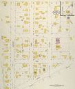
| Date: | 05 1926 |
|---|---|
| Description: | Section 1 of a Sanborn map of Osceola. |

| Date: | 05 1926 |
|---|---|
| Description: | Section 2 of a Sanborn map of Osceola. |
| Date: | 05 1926 |
|---|---|
| Description: | Section 3 of a Sanborn map of Osceola. |

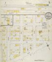
| Date: | 10 1911 |
|---|---|
| Description: | Section 1 of a Sanborn map of Osceola. |
| Date: | 10 1911 |
|---|---|
| Description: | Section 2 of a Sanborn Map of Osceola. |
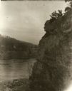
| Date: | 1929 |
|---|---|
| Description: | View of the rock formation known as the "Old Man of the Dalles" in the Interstate State Park near Saint Croix Falls, Wisconsin. The St. Croix River is in t... |
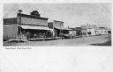
| Date: | 1905 |
|---|---|
| Description: | View across street towards businesses along the left. Caption reads: "Main Street, West Luck, Wis." |
| Date: | 1905 |
|---|---|
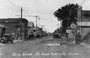
| Description: | View of Main Street, looking north towards businesses along the left side of the street. |
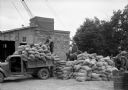
| Date: | 07 1938 |
|---|---|
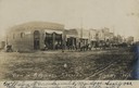
| Description: | Loading a truck with bait at the county mixing station at Balsam Lake during the grasshopper outbreak in northwestern Wisconsin. |
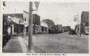
| Date: | 1930 |
|---|---|
| Description: | View from sidewalk on left side of bridge towards Main Street. Caption reads: "Main Street, Looking North, Osceola, Wis." |
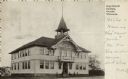
| Date: | 1905 |
|---|---|
| Description: | Exterior view of Osceola High School, with people standing near the entrance. Caption reads: "High School Building, Osceola, Wisconsin." |
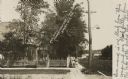
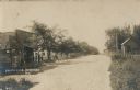
| Date: | 1908 |
|---|---|
| Description: | Photographic postcard view of Harriman Avenue in the residential district. A little girl is standing with her baby carriage on the sidewalk between a telep... |
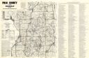
| Date: | 1980 |
|---|---|
| Description: | This road map of Polk County, Wisconsin, has been annotated to show the location of historic sites in the county and is accompanied by a 1980 directory of ... |
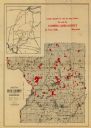
| Date: | 1900 |
|---|---|
| Description: | This map of Polk County, Wisconsin, from the early 20th century shows the land for sale by the Cushing Land Agency of Saint Croix Falls. The township and r... |
If you didn't find the material you searched for, our Library Reference Staff can help.
Call our reference desk at 608-264-6535 or email us at: