Filter: Categories of Wisconsin Historical Images
Filter: County of Polk
Filter: Subject of transportation
Filter: Categories of Wisconsin Historical Images
Filter: County of Polk
Filter: Subject of transportation
| Date: | 1905 |
|---|---|
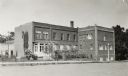
| Description: | Exterior view of Osceola High School, with people standing near the entrance. Caption reads: "High School Building, Osceola, Wisconsin." |

| Date: | |
|---|---|
| Description: | Children playing on swing set in front of an automobile. A man is seated on a picnic table nearby. |

| Date: | 2008 |
|---|---|
| Description: | Built sometime in the mid-1930s, this unique station, located at 118 Highway 35, visually illustrates its ongoing changes and success over time as it respo... |

| Date: | 2008 |
|---|---|
| Description: | This Art Moderne service station located at 202 North Cascade Street was built in 1947. With its dramatically curved facade, it undoubtedly grabbed the att... |
| Date: | |
|---|---|
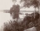
| Description: | View of a rural lake with a footbridge leading to a small island. |
| Date: | 1908 |
|---|---|
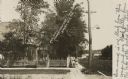
| Description: | Photographic postcard view of Harriman Avenue in the residential district. A little girl is standing with her baby carriage on the sidewalk between a telep... |
| Date: | 1980 |
|---|---|
| Description: | This road map of Polk County, Wisconsin, has been annotated to show the location of historic sites in the county and is accompanied by a 1980 directory of ... |
| Date: | 1900 |
|---|---|
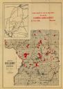
| Description: | This map of Polk County, Wisconsin, from the early 20th century shows the land for sale by the Cushing Land Agency of Saint Croix Falls. The township and r... |

| Date: | 1911 |
|---|---|
| Description: | This map of Polk County, Wisconsin, from the early 20th century shows the land for sale by the Baker Land and Title Co. of Saint Croix Falls. The township ... |

| Date: | |
|---|---|
| Description: | This map from the early 20th century shows the township and range grid, towns, sections, cities and villages, railroads, roads, schools, churches, and stre... |
| Date: | |
|---|---|
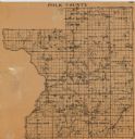
| Description: | This map of Polk County, Wisconsin, from the first half of the 20th century, shows the township and range grid, towns, sections, villages, roads, railroads... |

| Date: | 1901 |
|---|---|
| Description: | Map shows townships, schools, creameries, post offices, and roads. The left side of the map features a legend with symbols for points of interest. |

| Date: | 1914 |
|---|---|
| Description: | Map shows townships, schools, creameries, post offices, and roads. The left side of the map features a legend with symbols for points of interest. |

| Date: | 1871 |
|---|---|
| Description: | Map created between 1871 and 1880. Shows townships, post offices, a possible railroad to Penoka Iron Range, and the North Wisconsin Railroad. |

| Date: | 1890 |
|---|---|
| Description: | Map shows St. Croix, Wisconsin and a small portion of Taylor's Falls, Minnesota. Map reads: "The Lands shaded show the Mill & Riparian Reservation & unplat... |

| Date: | 1969 |
|---|---|
| Description: | Map showing St. Croix Falls and Taylors Falls, Minnesota. The map was produced by the St. Croix Falls Chamber of Commerce and Taylor Falls Commercial Club.... |

| Date: | |
|---|---|
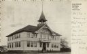
| Description: | Photographic postcard view of the exterior of the Court House. A large belfry is above the arched entrance way. |

| Date: | 1936 |
|---|---|
| Description: | Picnic area at Interstate Park showing parked automobiles and visitors. |
| Date: | 1900 |
|---|---|
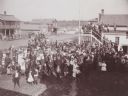
| Description: | Elevated view of crowd of men, women and children, gathered for some unidentified occasion, standing in the street. There is also a group of people gathere... |
If you didn't find the material you searched for, our Library Reference Staff can help.
Call our reference desk at 608-264-6535 or email us at: