Filter: Categories of Wisconsin Historical Images
Filter: County of Polk
Filter: Subject of transportation
Filter: Creator Name of Unknown
Filter: Categories of Wisconsin Historical Images
Filter: County of Polk
Filter: Subject of transportation
Filter: Creator Name of Unknown
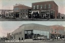
| Date: | 1905 |
|---|---|
| Description: | Top view is from the intersection looking towards buildings on the right side of the street. The bottom view has a caption that reads: "West Side of Main S... |
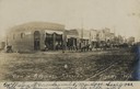
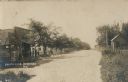
| Date: | 1905 |
|---|---|
| Description: | View down Keller Avenue towards businesses along the left. A round or octagon shaped building on the far left has a sign that reads: "Restaurant". Further ... |
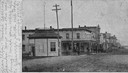
| Date: | 1905 |
|---|---|
| Description: | Business section of downtown. View across unpaved road towards business along the left. A group of children and adults are posing standing in the road nea... |
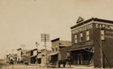
| Date: | 1905 |
|---|---|
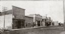
| Description: | West side of Main Street, with "The One Price Store" in the right foreground, and other commercial buildings further down the street. There are large utili... |
| Date: | 1905 |
|---|---|
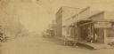
| Description: | View down a dirt road with a general store on the left, with a sign that reads: "Merchandise". Men and a child are standing on the porch. On the right side... |
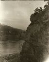
| Date: | 1929 |
|---|---|
| Description: | View of the rock formation known as the "Old Man of the Dalles" in the Interstate State Park near Saint Croix Falls, Wisconsin. The St. Croix River is in t... |
| Date: | 1905 |
|---|---|
| Description: | View across street towards businesses along the left. Caption reads: "Main Street, West Luck, Wis." |
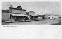
| Date: | 1905 |
|---|---|
| Description: | View of Main Street, looking north towards businesses along the left side of the street. |
| Date: | 1895 |
|---|---|
| Description: | View down Main Street. Will Brothers Meat Market can be seen on the right corner, and a tinshop is beside it on the left. |
| Date: | 1930 |
|---|---|
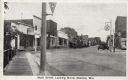
| Description: | View from sidewalk on left side of bridge towards Main Street. Caption reads: "Main Street, Looking North, Osceola, Wis." |
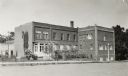
| Date: | 1905 |
|---|---|
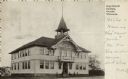
| Description: | Exterior view of Osceola High School, with people standing near the entrance. Caption reads: "High School Building, Osceola, Wisconsin." |

| Date: | 1871 |
|---|---|
| Description: | Map created between 1871 and 1880. Shows townships, post offices, a possible railroad to Penoka Iron Range, and the North Wisconsin Railroad. |

| Date: | 1890 |
|---|---|
| Description: | Map shows St. Croix, Wisconsin and a small portion of Taylor's Falls, Minnesota. Map reads: "The Lands shaded show the Mill & Riparian Reservation & unplat... |

| Date: | |
|---|---|
| Description: | Photographic postcard view of the exterior of the Court House. A large belfry is above the arched entrance way. |

| Date: | 1910 |
|---|---|
| Description: | Elevated black and white photographic postcard of Lake Cemelia, with boathouse and pier. |

| Date: | 1874 |
|---|---|
| Description: | This map shows townships and sections, post offices, roads, and railroads. The left margin reads: "For sale at Cushing Land Agency, St. Croix Falls, Wis. 4... |
| Date: | |
|---|---|
| Description: | View from hill of Frederic, with a creamery in the center. Three men are standing near the doorway of the creamery, and an automobile is parked in front. H... |
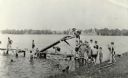
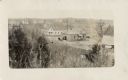
| Date: | |
|---|---|
| Description: | View from shoreline of a lake towards several children climbing or standing on a wooden pier. On the side of the pier is a wooden slide that angles into th... |

| Date: | 1940 |
|---|---|
| Description: | An elevated view of the St. Croix River at Interstate Park. There is a boat with open sides, probably an excursion boat, going down the river, and rock for... |
If you didn't find the material you searched for, our Library Reference Staff can help.
Call our reference desk at 608-264-6535 or email us at: