 Filter: Categories of Wisconsin Historical Images
Filter: County of Polk
Filter: Subject of streams
Filter: Categories of Wisconsin Historical Images
Filter: County of Polk
Filter: Subject of streams
| Date: | 1900 |
|---|---|
| Description: | This map of Polk County, Wisconsin, from the early 20th century shows the land for sale by the Cushing Land Agency of Saint Croix Falls. The township and r... |

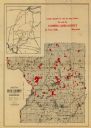
| Date: | 1911 |
|---|---|
| Description: | This map of Polk County, Wisconsin, from the early 20th century shows the land for sale by the Baker Land and Title Co. of Saint Croix Falls. The township ... |

| Date: | |
|---|---|
| Description: | This map from the early 20th century shows the township and range grid, towns, sections, cities and villages, railroads, roads, schools, churches, and stre... |
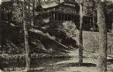
| Date: | 07 13 1918 |
|---|---|
| Description: | View of Seven Pines Lodge, a north woods resort. A log structure is on a hill, and a stream is at the bottom of the steps. Caption reads: "'Seven Pines' Le... |

| Date: | 1945 |
|---|---|
| Description: | Elevated view across water towards Holstein cattle in a pasture. Caption from calendar: "A Holstein dairy herd — Polk county. Wisconsin's fame as America's... |
If you didn't find the material you searched for, our Library Reference Staff can help.
Call our reference desk at 608-264-6535 or email us at: