 Filter: Categories of Wisconsin Historical Images
Filter: County of Polk
Filter: Subject of service industries
Filter: Categories of Wisconsin Historical Images
Filter: County of Polk
Filter: Subject of service industries
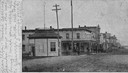
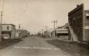
| Date: | 1905 |
|---|---|
| Description: | View down Keller Avenue towards businesses along the left. A round or octagon shaped building on the far left has a sign that reads: "Restaurant". Further ... |
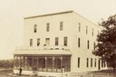
| Date: | 1898 |
|---|---|
| Description: | Balsam Lake Hotel. A person is standing just outside of the hotel. A fence and tree are on the right. |
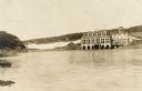
| Date: | 1905 |
|---|---|
| Description: | View upriver towards a dam, and a power house on the right. |
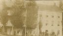
| Date: | 1900 |
|---|---|
| Description: | Exterior view of the St. Croix House with a large group of people lined up outside. |

| Date: | 2008 |
|---|---|
| Description: | Built sometime in the mid-1930s, this unique station, located at 118 Highway 35, visually illustrates its ongoing changes and success over time as it respo... |

| Date: | 2008 |
|---|---|
| Description: | This Art Moderne service station located at 202 North Cascade Street was built in 1947. With its dramatically curved facade, it undoubtedly grabbed the att... |

| Date: | 1901 |
|---|---|
| Description: | Map shows townships, schools, creameries, post offices, and roads. The left side of the map features a legend with symbols for points of interest. |

| Date: | 1871 |
|---|---|
| Description: | Map created between 1871 and 1880. Shows townships, post offices, a possible railroad to Penoka Iron Range, and the North Wisconsin Railroad. |

| Date: | 1969 |
|---|---|
| Description: | Map showing St. Croix Falls and Taylors Falls, Minnesota. The map was produced by the St. Croix Falls Chamber of Commerce and Taylor Falls Commercial Club.... |

| Date: | 1874 |
|---|---|
| Description: | This map shows townships and sections, post offices, roads, and railroads. The left margin reads: "For sale at Cushing Land Agency, St. Croix Falls, Wis. 4... |

| Date: | 1960 |
|---|---|
| Description: | This blue line print map shows pipes, valves, well site, and elevation tank, as well as lot and block numbers and dimensions. The map includes inset of con... |
| Date: | 1920 |
|---|---|
| Description: | View down center of Main Street. The State Bank is in the foreground on the right. A hardware store and hotel are on the left. There is a windmill in the d... |
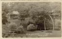
| Date: | 01 20 1916 |
|---|---|
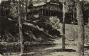
| Description: | Elevated view across lawn and river toward two buildings on a hill, including the main lodge on the right. A stairway leads down to the river on the right,... |
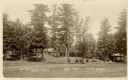
| Date: | 01 20 1916 |
|---|---|
| Description: | Exterior view of the grounds at the Seven Pines Lodge. Three buildings are in the distance. Caption reads: "At The Seven Pines, Lewis, Wis." |
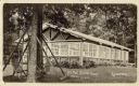
| Date: | 01 20 1916 |
|---|---|
| Description: | Exterior view of a building with windowed walls. In the foreground is a lawn swing. Caption reads: "At The Seven Pines, Lewis, Wis." Text on back reads: "T... |
| Date: | 01 20 1916 |
|---|---|
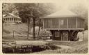
| Description: | Exterior view of a boathouse, with a canoe on the water nearby. There are two bridges, and abuilding is on hill in the background on the left. Caption read... |

| Date: | 10 1937 |
|---|---|
| Description: | A woman identified as Beth Doane is sitting on a rock formation high above the St. Croix River. She is looking into one of several potholes in the area. Th... |
| Date: | 07 13 1918 |
|---|---|
| Description: | View of Seven Pines Lodge, a north woods resort. A log structure is on a hill, and a stream is at the bottom of the steps. Caption reads: "'Seven Pines' Le... |
If you didn't find the material you searched for, our Library Reference Staff can help.
Call our reference desk at 608-264-6535 or email us at: