Filter: Categories of Wisconsin Historical Images
Filter: County of Polk
Filter: Subject of roads
Filter: Categories of Wisconsin Historical Images
Filter: County of Polk
Filter: Subject of roads
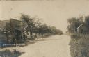
| Date: | 1905 |
|---|---|
| Description: | View down a dirt road with a general store on the left, with a sign that reads: "Merchandise". Men and a child are standing on the porch. On the right side... |

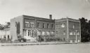
| Date: | 2008 |
|---|---|
| Description: | Built sometime in the mid-1930s, this unique station, located at 118 Highway 35, visually illustrates its ongoing changes and success over time as it respo... |
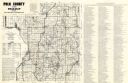
| Date: | 1980 |
|---|---|
| Description: | This road map of Polk County, Wisconsin, has been annotated to show the location of historic sites in the county and is accompanied by a 1980 directory of ... |
| Date: | 1900 |
|---|---|
| Description: | This map of Polk County, Wisconsin, from the early 20th century shows the land for sale by the Cushing Land Agency of Saint Croix Falls. The township and r... |

| Date: | 1911 |
|---|---|
| Description: | This map of Polk County, Wisconsin, from the early 20th century shows the land for sale by the Baker Land and Title Co. of Saint Croix Falls. The township ... |

| Date: | |
|---|---|
| Description: | This map from the early 20th century shows the township and range grid, towns, sections, cities and villages, railroads, roads, schools, churches, and stre... |
| Date: | |
|---|---|
| Description: | This map of Polk County, Wisconsin, from the first half of the 20th century, shows the township and range grid, towns, sections, villages, roads, railroads... |

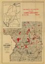
| Date: | 1901 |
|---|---|
| Description: | Map shows townships, schools, creameries, post offices, and roads. The left side of the map features a legend with symbols for points of interest. |

| Date: | 1914 |
|---|---|
| Description: | Map shows townships, schools, creameries, post offices, and roads. The left side of the map features a legend with symbols for points of interest. |

| Date: | 1969 |
|---|---|
| Description: | Map showing St. Croix Falls and Taylors Falls, Minnesota. The map was produced by the St. Croix Falls Chamber of Commerce and Taylor Falls Commercial Club.... |

| Date: | 1936 |
|---|---|
| Description: | Picnic area at Interstate Park showing parked automobiles and visitors. |

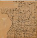
| Date: | 1874 |
|---|---|
| Description: | This map shows townships and sections, post offices, roads, and railroads. The left margin reads: "For sale at Cushing Land Agency, St. Croix Falls, Wis. 4... |
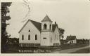
| Date: | |
|---|---|
| Description: | Exterior view from road towards the M.E. Church, a white wooden building with a bell tower. Caption reads: "M.E. Church, Centuria, Wis." |

| Date: | 1911 |
|---|---|
| Description: | View of a curving path, lined with trees and shrubs, leading to a bridge. A lawn is sloping down towards the shoreline on the right. |
If you didn't find the material you searched for, our Library Reference Staff can help.
Call our reference desk at 608-264-6535 or email us at: