 Filter: Categories of Wisconsin Historical Images
Filter: County of Polk
Filter: Subject of lakes
Filter: Categories of Wisconsin Historical Images
Filter: County of Polk
Filter: Subject of lakes
| Date: | |
|---|---|
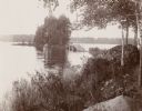
| Description: | View of a rural lake with a footbridge leading to a small island. |
| Date: | |
|---|---|
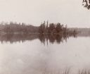
| Description: | View of Clear Lake from shoreline. A small, tree-covered island is visible, with a tree-lined shore in the background. |
| Date: | 1898 |
|---|---|
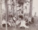
| Description: | A group of men, women, and children pose for a photograph as they relax in the woods around a large hammock. In the background is a shoreline. |
| Date: | 1908 |
|---|---|
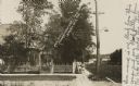
| Description: | Photographic postcard view of Harriman Avenue in the residential district. A little girl is standing with her baby carriage on the sidewalk between a telep... |
| Date: | 1900 |
|---|---|
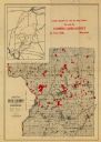
| Description: | This map of Polk County, Wisconsin, from the early 20th century shows the land for sale by the Cushing Land Agency of Saint Croix Falls. The township and r... |

| Date: | 1911 |
|---|---|
| Description: | This map of Polk County, Wisconsin, from the early 20th century shows the land for sale by the Baker Land and Title Co. of Saint Croix Falls. The township ... |

| Date: | |
|---|---|
| Description: | This map from the early 20th century shows the township and range grid, towns, sections, cities and villages, railroads, roads, schools, churches, and stre... |

| Date: | 1901 |
|---|---|
| Description: | Map shows townships, schools, creameries, post offices, and roads. The left side of the map features a legend with symbols for points of interest. |

| Date: | 1914 |
|---|---|
| Description: | Map shows townships, schools, creameries, post offices, and roads. The left side of the map features a legend with symbols for points of interest. |
| Date: | 1910 |
|---|---|
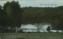
| Description: | Colorized postcard view down hill toward the lake. Caption reads: "South Clear Lake, Wis." |

| Date: | 1910 |
|---|---|
| Description: | Elevated black and white photographic postcard of Lake Cemelia, with boathouse and pier. |

| Date: | 1900 |
|---|---|
| Description: | This photocopy map shows landownership and mills in T35N, R17W as it appeared in 1885. Rice Lake, Little Balsam Lake, and Half Moon Lake are labeled. |
| Date: | |
|---|---|
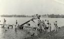
| Description: | View from shoreline of a lake towards several children climbing or standing on a wooden pier. On the side of the pier is a wooden slide that angles into th... |
If you didn't find the material you searched for, our Library Reference Staff can help.
Call our reference desk at 608-264-6535 or email us at:
