 Filter: Categories of Wisconsin Historical Images
Filter: County of Ozaukee
Filter: Categories of Wisconsin Historical Images
Filter: County of Ozaukee
| Date: | |
|---|---|
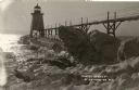
| Description: | View of ice coated pier and lighthouse along the shore of Lake Michigan. Caption reads: "Winter Scene at Port Washington, Wis." |
| Date: | |
|---|---|
| Description: | Postcard view along icy shoreline of the pier and lighthouse on Lake Michigan at Port Washington in winter. |
| Date: | |
|---|---|
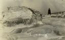
| Description: | Winter postcard view of the pier and lighthouse at Port Washington seen from the icy shore of Lake Michigan. Caption reads: "Light House." |
| Date: | |
|---|---|
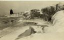
| Description: | Winter view of the lighthouse at Port Washington from the icy shore of Lake Michigan. Two people can be seen standing on a pier in the distance. |
| Date: | 1910 |
|---|---|
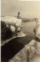
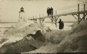
| Description: | Postcard view of three men on an elevated walk on an icy pier near the shoreline. A women and young boy stand on the pier below the walk. There is a lighth... |

| Date: | 01 1971 |
|---|---|
| Description: | L.J. Brodd and Mrs. Robert Rasche, both of Glendale, sweep ahead of the stone during a match as part of the 21st Annual Milwaukee Mixed Bonspiel. Mrs. Jane... |
| Date: | 1956 |
|---|---|
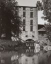
| Description: | View across water of the Old Mill surrounded by trees and water. Water is coming out of an opening in an archway of the mill. On the left automobiles are p... |

| Date: | 1967 |
|---|---|
| Description: | This map of Cedarburg includes a list of historic buildings in the left margin. The map was created by the Ozaukee County Historical Society for Cedarburg'... |
| Date: | 1906 |
|---|---|
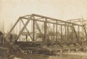
| Description: | Steel span railroad bridge under construction over Cedar Creek. |

| Date: | 1938 |
|---|---|
| Description: | This map shows plat of town, boundary lines of assessors blocks, land ownership by name, local streets, railroads, wards, lots, and parts of Cedar Creek. T... |

| Date: | |
|---|---|
| Description: | View down center of downtown street in Port Washington. Night view showing electric lights, neon signs and falling snowflakes. |

| Date: | 1910 |
|---|---|
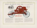
| Description: | Catalog cover for Gasoline Engines, Types T. Z. Y. W. "Goes like sixty." |
| Date: | 1910 |
|---|---|
| Description: | Inside spread of catalog, featuring a color illustration of a portable engine. Text reads: "Gilson 100% Service Portable Engine — 4, 5, 6 and 8 H.P." Inset... |

| Date: | 1910 |
|---|---|
| Description: | Front page of Gilson Manufacturing Company brochure, with the title: "The engine that saves the wheat." Features an image of two men using the attachment i... |

| Date: | 1876 |
|---|---|
| Description: | This map shows existing and proposed harbor improvements, streets, the Sauk River, and Lake Michigan. On the bottom of the map inscribed in ink is: "44th C... |

| Date: | 01 09 1958 |
|---|---|
| Description: | Elevated view from bluff of the harbor towards the southeast. At the end of a jetty is a lighthouse on the left. The water is frozen along the shoreline. T... |

| Date: | 01 09 1958 |
|---|---|
| Description: | View of Port Washington Harbor from Wisconsin Electric Power Company wharf. The city is in the background along the shoreline. |
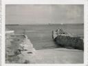
| Date: | 07 27 1960 |
|---|---|
| Description: | View from shoreline at Port Washington south of two ramps within a breakwater. There is a lighthouse in the background. Boats are along a pier on the right... |

| Date: | 1989 |
|---|---|
| Description: | This pictorial map shows Lake Michigan, businesses with phone numbers, schools, parks, other points of interest, and includes a brief history of the town. ... |

| Date: | 1960 |
|---|---|
| Description: | This blue line print map shows zone districts, lot and block numbers and dimensions, building setbacks, center lines of streets, and some landownership. Th... |
If you didn't find the material you searched for, our Library Reference Staff can help.
Call our reference desk at 608-264-6535 or email us at: