 Filter: Categories of Wisconsin Historical Images
Filter: County of Ozaukee
Filter: Year of 1800-1899
Filter: Subject of architecture
Filter: Categories of Wisconsin Historical Images
Filter: County of Ozaukee
Filter: Year of 1800-1899
Filter: Subject of architecture

| Date: | 1882 |
|---|---|
| Description: | This map of Cedarburg is a bird's-eye map with an inset of Cedarburg Brewery. Relief is shown pictorially and the map includes an index to buildings. |

| Date: | 1872 |
|---|---|
| Description: | Wind powered stone grist mill. Two men stand on a wood balcony near the open doorway of the windmill. |

| Date: | 1847 |
|---|---|
| Description: | An artists rendition of the western view of the Thiensville mills from the local tavern. Caption reads: "West View of Thiensville Mills from the Tavern." |
| Date: | 1884 |
|---|---|
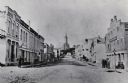
| Description: | A distant view of St. Mary's Church. Looking north from the corner of Main and Franklin Streets. |
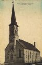
| Date: | 1891 |
|---|---|
| Description: | Hand-colored view of First Imanuels Church. A brick building with arched windows, bell tower and steeple. Caption reads: "First Imanuels Church, Cedarburg,... |
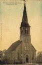
| Date: | 1891 |
|---|---|
| Description: | Hand-colored view of Trinity Lutheran Church on Columbia Road, a stone building with a clock in the bell tower/steeple. Arched windows are on the front and... |

| Date: | 1871 |
|---|---|
| Description: | View toward the church, which is a stone building with a clock in the bell tower/steeple. Arched windows are on the front and sides. A fence is running alo... |
If you didn't find the material you searched for, our Library Reference Staff can help.
Call our reference desk at 608-264-6535 or email us at:
